CityWater

Importing Data into CityWater

Do you have a project you want to import into CityWater? CityWater manages water distribution network models across local areas. Furthermore it empowers organizations to allow accessing and viewing of projects by multiple users.

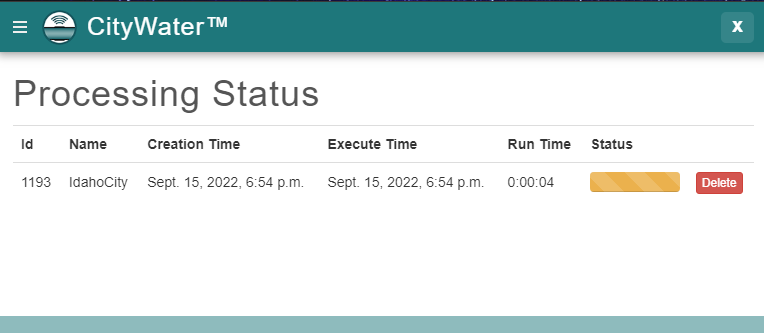
A Citywater project is based on an initial project created in EPANET or Aquaveo's Watershed Modeling System (WMS). Once you have an EPANET project, you can upload it to the CityWater site. Currently, CityWater only accepts EPANET INP files. If you need to, you can download an EPANET application to convert a file to an INP file. Uploading may take some time depending on multiple factors such as:

  • The size of the file being uploaded
  • The availability of the server
  • The complexity of the area modeled in the file
  • Including fire flow options with the import

Uploading can range anywhere from less than a minute to twenty minutes or longer.

Processing status for CityWater INP import

Note that you cannot edit your uploaded file once it has been uploaded into CityWater. Any changes that need to be made to the model will need to be made in EPANET or Aquaveo's WMS application. It is strongly encouraged to review the INP file before importing it into CityWater.

If you have discovered that the imported project either needs changes or did not import correctly, you will likely need to delete the entire project, start over, and reupload the newly changed project. For this reason, we recommend that you review the project after it finishes uploading, before proceeding with using the tools in CityWater.

If the project file failed to import into CityWater, it could for a few different reasons:

  • There was an issue communicating with the server
  • The file is not a recognized file type
  • There is an issue with the CityWater new project parameters
  • There is an issue with the INP file
  • There is an issue with the EPANET project design

In most cases, these issues can be resolved by reviewing the INP file and attempting to import the file again. Try importing your EPANET file to CityWater today!

Blog tags: 

Using Plots in CityWater

Any presentation about water distribution management can be improved with the right plots. CityWater has a number of different plots accessible through the plot icon on the Map View page that can be used by you to visualize the information available in each of your projects. These plots can be used in reports or presentations to help others understand details and specific time-based information you need to share.

The Plot icon on the Map view is a dynamic tool. If no nodes or links are selected, it will display a System Flow Balance plot when clicked. This plot shows the flow produced, consumed, and stored within your pipe network. You can select any point along each of the plot lines to see specific for that time.

CityWater System Flow Balance Flow

If you have a specific link or node selected (or more than one of either nodes or links selected), you can use the Layers tab drop-downs to select what will appear on the plot. This gives you a large number of possibilities for how the plot will appear. Some combinations do not have a plot available, and these will instead show the default System Flow Balance plot. We recommend taking the time to play around with the options to find the ones that will work best for you.

For example, the image below shows a plot with Demand, Links, and Minimum selected from the Node Layer, Link Layer, and Time drop-downs (respectively). As before, you can select any point along the plots to see specific details for the desired node or link.

CityWater Demand Plot

CityWater contains many other tools to help you visualize water flow and usage in your water distribution network all in an accessible and a convenient to use web environment. Learn more about how CityWater can help your organization today!

Blog tags: 

Exporting Data in CityWater

CityWater allows managing your water distribution network models. As an online application, it allows individuals across the organization to visualize, reference, and analyze existing models in a familiar map-based browser environment while maintaining the data integrity of the model.

When viewing the project details, the Export tab allows three different files to be exported for your use in other applications: a Report Map Shapefile, a Network Map Shapefile, and an EPANET Input File.

Export tab in CityWater

The Report Map Shapefile allows you to select the Variable and Time options to include in the file. For Variable, you can select from head, pressure, quality (links), quality (nodes), demand, pressure swing, velocity, or headloss. The time options include average, minimum, or maximum. Based on the selections, a shapefile with those options will be exported when you click the Export Report Map button.

The Export Network Map button under the Network Map Shapefile option will export a shapefile of the network map, including all the links/pipes, nodes/junctions, and other features. This can then be imported into WMS or any other application that works with distribution networks.

The final option, EPANET Input File, creates an EPANET input file that can be used in any application that can import it. This plain text file contains all the pipe networks information, including pipes, nodes (junctions), pumps, valves, storage tanks, and reservoirs. It also contains additional project and preference information used by the EPANET desktop application.

An additional option allows you to save the current view when in the Map view:

  1. Adjust the map view to how you want it
  2. Right-click anywhere on the map and select Save image as…

This will automatically save the current map view as “download.png” in your downloads location on your computer.

Try out these export features today by logging in at https://portal.aquaveo.com/. If you don’t have an account, use "trycitywater" as the username and password to see an example project.

You can also learn more about using CityWater by watching our tutorial videos.

Blog tags: 

Aquaveo User Conference 2019

The 2019 Aquaveo User Conference is going on now. It started yesterday, October 8th, and will wrap up today, October 9th. We are enjoying meeting with users from around the world. In attendance are users from the United States, Germany, Portugal, South Africa, and other places around the globe.

At the conference, we announced some of the new features and upcoming changes to our products that we are excited about:

  • Making XMS functionality available for use outside of the traditional interface.
  • More web-based applications for portability and ease of access.
  • Simplifying and unifying tools so it is easier to find and use the functionalities available.
  • Project management tools to track the history of a model.
  • 3D bridge modeling in SMS.
2019 Aquaveo User Conference

Talking to those in attendance, we learned they enjoyed:

  • Learning more about software features and functionality.
  • Learning how to improve their model development process.
  • Discovering benefits of Aquaveo’s software over other software.
  • Talking to developers and learning tips for model development.
  • Being able to show off their models and receive feedback on them.
Eva Loch presenting at the 2019 Aquaveo User Conference

We’d like the thank the following for participating during our user conference:

If you couldn’t make it to the Aquaveo User Conference this year, watch our website and Facebook page for future conferences.

Pages