Aquaveo & Water Resources Engineering News

Using Rasters with Map to MODFLOW
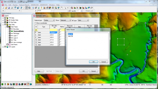
For some time GMS has included the capability to use TINs with the Map->MODFLOW command. The next version of GMS will also include the capability to use Rasters with the Map->MODFLOW command similar to how TINs can be used now. In the conceptual model, the user will associate the desired Raster with the Head/Elevation assigned to a point, node, arc, or polygon. When the Map->MODFLOW command is executed the Head/Elevation for the boundary condition is extracted from the Raster using the cell center where the boundary condition is applied. The figure below shows how/where the Raster can be assigned to a point/node/arc/polygon.

Map to MODFLOW Raster
Blog tags: 

GMS Sprint November 2013

  • Released GMS 9.2
  • Fixed 11 bugs
  • Conducted training in Australia
  • Implemented exporting of faces to CAD
  • Help buttons on wizards now goes to correct wiki or offline help page
  • More progress with improved native MODFLOW text files
  • Good progress on MODFLOW-USG support
  • Help buttons for Qt dialogs no work
  • Tutorial sample files open without prompting for missing file locations
  • Added color and improved readability of model checker dialog
  • Fixed problems with View Previous in ortho mode
Blog tags: 

GMS Sprint October 2013

  • Fixed 3 bugs
  • Branched version 9.2
  • Recorded three new videos for YouTube (not yet posted)
  • Improved test reporting in continuous build machines for MF-2000 and MF-2005
  • Removed copy protection in SEAWAT for GMS 9.1
  • Updated versions of MODFLOW-LGR and MODFLOW-NWT
  • Finished improving native MODFLOW text format for areal parameters
  • Completed design of CLN process interface
  • Created a 1D array editor dialog for MODFLOW-USG similar to 2D version
  • Got list package dialogs working for MODFLOW-USG
  • Fixed it so that 3D grids and Ugrid versions of MODFLOW can coexist
  • Got Sources/Sinks dialog working for MODFLOW-USG
  • Got LAK package dialog working for MODFLOW-USG
  • Got SUB package dialog working for MODFLOW-USG
  • Got CCF view values working for MODFLOW-USG
  • Got ZONEBUDGET working for MODLFOW-USG
  • Began conversion to Qt
  • Did some investigations of SWIG
  • Got Ugrid data sets working (import/export, save/restore, data calculator)
  • Saving Ugrid in VTK format in project (.gpr) file
Blog tags: 

September 2013 Sprint

  • PEMEX conference
  • LA County training
  • Fixed 5 bugs
  • MODFLOW-USG progress including:
    • Convert 3D grid to USG
    • STR package I/O
    • GAG package I/O
    • Read solution including head, drawdown, and CCF files
    • RCH and EVT package dialogs
    • Selecting USG cells
    • Displaying symbols in USG
  • MODFLOW text output progress including:
    • ETS, EVT, GAGE, LAK, MNW, OBS, RCH, SFR, STR, SUB, and UZF packages
  • Import MODFLOW well package data from text files
  • Updated to latest version of MF2K5
  • Pathlines -> Arcs command now works without capture zones
  • GeoPDF tests added
  • Branched version 9.2
Blog tags: 

PEMEX Conference

From Aug 26 to 30, PEMEX hosted the "Septimo Seminario International de Respuesta a Emergencias, Caracterizacion y Remediacion de Sitios Impactados por Hidrocarburos" in Mexico City, Mexico. The keynote speaker at the conference was Nobel laureate, Dr Mario Molina. He gave a presentation on global warming.

Alan Lemon from Aquaveo was invited to attend and give a presentation on using GMS for site characterization and flow and transport modeling of impacted sites. The presentation gave some background on the modeling process and how GMS can be used to characterize and model impacted sites. Another lecturer, Dr. Willis Weight, also shared many case studies of applied modeling using GMS. The attendees were particularly impressed with the visualizations demonstrated by Dr. Weight. Many thanks to the conference organizers for the invitation to present. Special thanks to Jorge Chirpas, Paula Andrea Martinez, and Cuauhtemoc Luna for their many efforts before, during, and after the conference.

 
Blog tags: 

GMS Training at Los Angeles Department of Water and Power

From August 12 to 15, members of the GMS team at Aquaveo conducted training for the Los Angeles Department of Water and Power (LADWP). The introductory Groundwater Flow and Transport Modeling class was presented to LADWP employees. The class included lectures, demos, hands on exercises, and daily tests to verify that the students could complete modeling problems. We covered MODFLOW, PEST, MODPATH,  and MT3DMS. Additionally we talked about borehole data, subsurface characterization, GIS data, and how to integrate this data into groundwater models. The class was a great success. The attendees really appreciated the power and simplicity of GMS and the conceptual modeling approach. Many thanks to the attendees.

August 2013 Sprint

  • Fixed 10 bugs
  • Training course in Los Angeles
  • Training course in Mexico City
  • MODFLOW-LGR support completed including MODPATH functionality and a second tutorial
  • Added DGN (MicroStation) file support
  • Added ISTCB1 option support in MODFLOW STR and SFR packages
  • Progress on improving native MODFLOW text output
  • Progress on open sourcing MODFLOW changes
  • Progress on MODFLOW-USG support
  • Added MODFLOW option to default starting heads to the grid top elevations
  • 3D Grid to shapefile export now lets user pick all, active, or selected data sets to export

July 2013 Sprint

  • Fixed 13 bugs
  • Posted a GMS 9.1 update
  • More progress on improving native MODFLOW text output
  • More progress on open sourcing MODFLOW changes
  • MODFLOW-LGR progress
  • MODFLOW-USG progress
  • Implemented smooth fonts. Fonts will look a lot better
  • Removed display of node in the middle of quad elements of a 2D mesh
  • Lots of code refactoring taking place
  • Attended the ESRI User Conference

ESRI International User Conference 2013

Join us at the 2013 ESRI International User Conference July 8-12, 2013 in San Diego, California. This year marks the 32nd convening on the International Conference on GIS technology. If you will be attending this conference, please stop by the Aquaveo booth to say hello. This conference typically enjoys a lot of support from the engineering community engaged in geographical information systems. It will be a great opportunity to connect with and learn from experts in the field.

Blog tags: 

MODFLOW and MORE 2013


We enjoyed seeing many of you at this year's MODFLOW and MORE 2013: TRANSLATING SCIENCE INTO PRACTICE conference. We had a booth, a couple of posters, and a couple of presentations this year. One poster showed MODFLOW-USG refined grids of different types. The other poster was on MODFLOW Server (images below). Dr. Norm Jones gave a very interesting presentation on Monday on his paper entitled Debating the Long-Term Impact of the Southern Nevada Pumping Project based on consulting work done at Aquaveo. One of Norm's graduate students, Scott Christensen presented on Wednesday on his paper entitled A web-based groundwater mapping and visualization tool using Google Earth which is based on work done partly at Aquaveo and partly at BYU.
Software demo. Photo courtesy of  igwmc.

The booth. Photo courtesy of igwmc.


Pages