Tethys

Exporting Data in CityWater
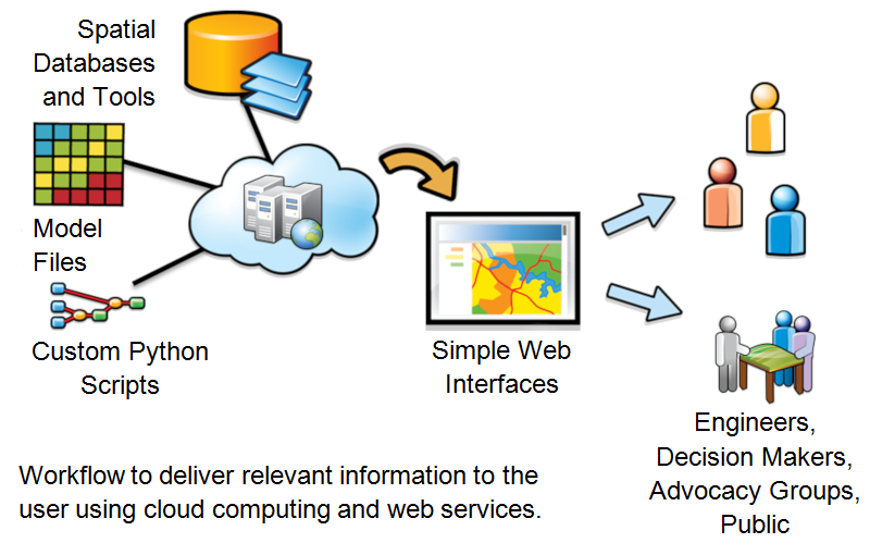
CityWater allows managing your water distribution network models. As an online application, it allows individuals across the organization to visualize, reference, and analyze existing models in a familiar map-based browser environment while maintaining the data integrity of the model.

When viewing the project details, the Export tab allows three different files to be exported for your use in other applications: a Report Map Shapefile, a Network Map Shapefile, and an EPANET Input File.

Export tab in CityWater

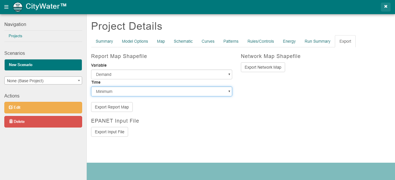
The Report Map Shapefile allows you to select the Variable and Time options to include in the file. For Variable, you can select from head, pressure, quality (links), quality (nodes), demand, pressure swing, velocity, or headloss. The time options include average, minimum, or maximum. Based on the selections, a shapefile with those options will be exported when you click the Export Report Map button.

The Export Network Map button under the Network Map Shapefile option will export a shapefile of the network map, including all the links/pipes, nodes/junctions, and other features. This can then be imported into WMS or any other application that works with distribution networks.

The final option, EPANET Input File, creates an EPANET input file that can be used in any application that can import it. This plain text file contains all the pipe networks information, including pipes, nodes (junctions), pumps, valves, storage tanks, and reservoirs. It also contains additional project and preference information used by the EPANET desktop application.

An additional option allows you to save the current view when in the Map view:

  1. Adjust the map view to how you want it
  2. Right-click anywhere on the map and select Save image as…

This will automatically save the current map view as “download.png” in your downloads location on your computer.

Try out these export features today by logging in at https://portal.aquaveo.com/. If you don’t have an account, use "trycitywater" as the username and password to see an example project.

You can also learn more about using CityWater by watching our tutorial videos.

Blog tags: 

Bringing Water Stability to the World

A project that Aquaveo is proud to be part of is bringing forecasting data to people around the globe through GEOGLOWS.

Because many countries around the world don’t have the resources to predict droughts and floods, they struggle to keep a steady supply of food and stable economy. Companies such as the World Bank, ESRI, NASA and others have partnered together to create a warehouse of apps to predict a 15-day forecast of more than 200,000 streams across four continents to help anyone from farmers to politicians be better prepared for any changes.

GEOGLOWS workflow

Though Aquaveo only came onto this project recently, designing an API for these apps, we are very excited to be helping countries around the world such as Somalia and Ethiopia overcome their struggles to stabilize their economies, and be better prepared for disasters.

Two of Somalia’s main rivers, the Juba and Shebelle rivers, originate outside of their boundaries in Ethiopia and Kenya, which is a major obstacle for Somalia. A streamflow forecasting system helps improve water management in the country by providing much needed transboundary water information--helping them foresee flooding within days allowing them to take action.

Ethiopia gets between 40–87 inches of rain a year, both because of this much rainfall and in spite of this much rain, Ethiopia is vulnerable to floods, droughts, and chronic scarcity in several parts of the country. A streamflow forecasting system helps improve water management in the country by providing the necessary data to make decisions and develop action plans.

Since the formal creation of the initiative in 2017, the most significant element of GEOGLOWS has been the application of Earth Observations (EO) to create a system that forecasts flow on every river of the world while also providing a 35-year simulated historical flow. We can now deliver reliable forecast information as a service, instead of all the underlying data that must be synthesized and computed locally to produce the necessary information.

Aquaveo have been proud to be part of GEOGLOWS and other initiatives. Watch our website to see news about more projects like this in the future.

Blog tags: 

Take Advantage of the Cloud for Engineering

These days, everything seems to be in “the cloud”, and for good reason. No more having to email or manually deliver a flash drive or DVD containing the documents or data. Having it stored in one online location accessible to everyone on the project makes everything more convenient, and makes it far easier to collaborate with others in your organization.

As an example a cloud-based application, you can use CityWater on the Aquaveo Portal, to access municipal water distribution data from anywhere using a modern web browser. One person uploads an input file for the model which can then be accessed by anyone in the organization.

Once the model has be uploaded, you and your colleagues can create multiple scenarios to generate alternate models. This allows quick collaboration for group planning of municipal water distribution projects. Feedback and comments can be made from multiple contributors to help everyone have their say. CityWater does all this while maintaining the integrity and security of the original model.

Your whole process becomes much simpler because the CityWater controls are designed from the ground up to scale from desktop to tablet to smart phone, all without removing any of the functionality. So, whether you’re in your office or out on a work site, the relevant data can be easily accessed with just a few taps. New and updated information can also be entered on the fly to make the model results more specific and accurate.

Because it doesn’t have to be purchased and installed on every computer or device, CityWater is much more cost effective. This allows the cost per user to be significantly lower, and your IT department won’t be burdened with additional work. The software behind CityWater is regularly updated, so anytime you log in through the Aquaveo Portal, you are using the most current version.

Try out the CityWater tool today by going to the Aquaveo Portal. Use “trycitywater” as the username and password.

Blog tags: