Aquaveo & Water Resources Engineering News

Using the Select/Delete Data tool in SMS

Do you have a project that requires selecting a specific region of a mesh or grid to properly gather the necessary data for that area? For example, perhaps you need to select the mesh elements in the area of a bridge so that the elements can be refined. In order to accomplish either of this, there are a couple of options.

One option is to change the attributes directly within an already established mesh or grid by selecting individual cells, elements, or nodes. This could be very time consuming in a large mesh or grid.

Other selection tools, such as the Select by Poly tool, could be used. However, another option is to use the Select/Delete Data tool in SMS.

The Select/ Delete Data tool uses a polygon in the Map module to select objects in a grid, or mesh. It can also be used for selecting points or triangles in a scatter set or feature objects on a different map coverage. This can go quickly if you already have the desired polygon created on a map coverage, such as a materials coverage. Furthermore, the tool can be used to delete objects inside the select polygon.

Select/Delete Data in SMS

Only a few steps are needed in order to use the Select/ Delete Data tool.

  1. After locating the area that needs to be altered, use the Create Feature Arc tool to enclose the desired area or use an existing polygon.
  2. Next, build a polygon using the Feature Objects | Build Polygons menu command if you are not using an existing polygon.
  3. Select the polygon using the Select Polygon tool.
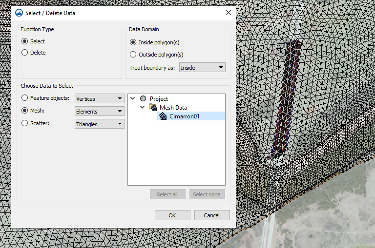
  4. Select the Feature Objects | Select/ Delete Data menu command.
  5. In the Select/Delete Data dialog, choose whether to select or delete the data and which data the function should be applied to.

The data options to choose from are based on what is in the project. You can also select what object in the data object to select or delete. For example, with a 2D mesh, you may choose to select the mesh elements, nodes, or duplicate nodes.

Try out the Select/Delete Data tool in SMS today!

Blog tags: 

3 New Features in GMS 10.5 Beta

We are happy to be announcing the beta release of GMS 10.5! Thanks to the hardworking developers here at Aquaveo there are a number of new and exciting features to this new version.

To name a few, we gathered a list of three new and improved features in GMS 10.5 beta release!

  1. MODFLOW 6 Grid Approach
    Additional functionality has been added for working with MODFLOW 6. A MODFLOW 6 model can now be built in GMS using the grid approach. The new MODFLOW 6 interface uses a simulation approach that is different from the interface for other MODFLOW applications in GMS. This approach also allows for multiple simulations to be included in a single project.
  2. TVM Package
    The TVM package is now available in GMS 10.5 for use with MODFLOW-USG Transport. The Time-Variant Materials (TVM) package allows the changing of hydraulic conductivity and storage values between stress periods. Through a transient simulation, it can also be used to change these parameters in a continuous manner not just in increments between stress periods. This will help display the different changes made to the project over time.
  3. TVM Package in GMS 10.5
  4. Tile map services (TMS) can now be used for import or background image display.
    In this new version of GMS the ability to import TMS into projects needing tile map services has been made available. This provides access to maps that can now be rendered to map tiles at fixed scales. Rather than trying to break down one large image, this helps to be able to view a map in a simpler way. It also helps to be able to pinpoint and save one particular tile of a map in case only that tile is needed as opposed to the entire image.

These are only some of the changes that have been made to the new beta release version of GMS. Explore even more of the changes by downloading GMS 10.5 beta from our downloads page.

Blog tags: 

Tethys Training in Kenya

Aquaveo was recently given the opportunity by NASA SERVIR to develop a training course involving the Tethys Platform. NASA SERVIR is a joint venture between NASA and the U.S. Agency for International Development.

RCMRD Building

SERVIR works to provide better informative forecasts regarding the risks of floods as well as an outline of what happens after the devastation of flooding in an area. Thus, it was exciting to participate in furthering their mission to provide state-of-the-art, satellite-based, and Earth monitoring data.

In partnership with NASA SERVIR, Aquaveo led in developing and delivering training courses on app development through the use of the Tethys Platform. The Tethys Platform provides a suite of free software which helps in creating water resource applications. Due to the unique system Tethys uses, less code and written HTML is needed for the development of applications. These are just a couple of things that make the Tethys Platform a useful resource for web developers.

From February 24th to the 28th, twenty-one individuals from Ghana, Senegal, Nepal, Columbia, Peru, USA, and Kenya traveled to the SERVIR Eastern and Southern Africa Hub at the Regional Centre for Mapping of Resources for Development (RCMRD), located in Naribi, Kenya to attend both a communicative and individualized training.

Tethy training in Kenya

The Regional Centre For Mapping Resource For Development has been dedicated to promoting sustainability through the use of GEO-information. Their aid in supplying tools and space for Aquaveo to lead a training on the Tethys Platform was another step toward promoting sustainable development world wide. After four days of training, each participant left with even more knowledge on app development and will in turn further the progress in the Regional Centre for Mapping of Resources for Development's (RCMRD's) mission.

Tethy training in Kenya

The majority of the training focused showing how to develop applications using the Tethys Platform. Each contributor also took part in a more individualized training where one of the four training days was entirely dedicated toward working on and receiving help with their own personal projects. Aquaveo enjoyed the time spent working with these amazing participants and can’t wait to do it again.

Two additional training courses will be provided by Aquaveo within the year. We have the opportunity to meet more participants and lead a training in the areas of Kathmandu, Nepal and Huntsville, Alabama.

Experience learning more about Tethys Platform app development and keep an eye out for more details about future training courses!

Blog tags: 

Tips for Sharing SRH-2D Project Files

In SMS, projects are saved out as a series of files. These files should be kept together when sending a project to a coworker or associate. The exact files needed often varies based on the numeric model being used. This article will discuss the files needed when sharing an SRH-2D project.

There are a few items to keep in mind when sharing your SRH-2D project files.

Make certain all of the files have been included when sending them to someone else. The core files that are generally needed include:

  • SMS project file (*.sms)
  • Map data file (*.map)
  • Mesh data file (*_meshes.h5)
  • Materials data file (*.materials)
  • Any GIS or image files such as TIFs, JPGs, or shapefiles

One of the easier ways to make certain all of these files are included, is to use the Save As Package menu command. This command is found in the File menu. Using this command will place all of the files listed above into a single ZIP file.

The Save As Package command
Solution Files
If you have already run SHR-2D and have solution files, these files should be included with the other files. When opening the project file, sometimes the solution files will not be visible. To import the SRH-2D solution, select the Open command, then locate the *_XMDF.h5 file and import it into the project.
HY-8 Culverts

When sharing an SRH-2D project that includes HY-8 culverts, be certain to include the HY-8 file. It also may be necessary for the person receiving the files to relaunch HY-8 before running SRH-2D again. This is done by doing the following:

  1. Right-click on the boundary condition coverage containing the culvert and select the HY-8 Options menu command.
  2. Select the HY-8 file.
  3. Select the HY-8 arcs, then right-click and select the Assign Linear BC command.
  4. Launch HY-8.
Restart Files

If the project used a restart file, be certain to also include the *.rst file with the project. In some cases, this file needs to be specified again in the SRH-2D Model Control dialog before running SRH-2D.

Keeping track of all of the files necessary for an SRH-2D project makes certain the project can be used by anyone. Explore SRH-2D and other models in SMS today!

Blog tags: