We use cookies to make your experience better. To comply with the new e-Privacy directive, we need to ask for your consent to set the cookies. Learn more.

Discover MODRAT Percent Impervious
When working with the Watershed Modeling System (WMS) and the MODRAT model, one potential aspect of your watershed analysis would be determining the percent impervious values for each sub-basin. Accurate percent impervious calculations may significantly influence your hydrologic modeling outcomes. Here is a guide to help you navigate this process effectively.
Importing Land Use Data
To compute the percent impervious for each sub-basin in MODRAT, you need to start with accurate land use data. Land use data in WMS is typically stored in the GIS and Map modules. The most efficient way to read this data into WMS is through a shapefile. Here’s how you can do it:
- Create a Land Use Coverage: In WMS, start by creating a new land use map coverage. This coverage will hold all the land use data you import.
- Import the Polygon File: Import your land use polygon shapefile into WMS. This file should contain various land use types and their respective boundaries.
- Assign the Percent Impervious Field: Ensure that the percent impervious field, often labeled as IMPERV_ by the Los Angeles County Department of Public Works (LACDPW), is correctly mapped to the LA County Soil land use field in WMS. This step is crucial as it links the impervious data to your land use coverage.
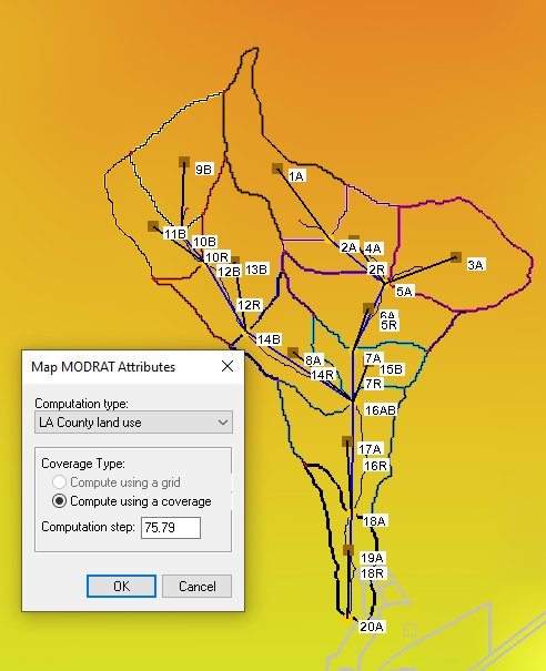
- Compute and Assign Percent Impervious: With the land use data now present in WMS, use the "Map Attributes" command in the MODRAT menu to compute and assign the percent impervious values. This function will analyze the land use data and calculate the percent impervious for each sub-basin.
Using Coverage Overlay Options
Another method to determine the percent impervious values is by using the Coverage Overlay options in WMS. This approach is similar to calculating curve numbers and involves overlaying land use coverage with drainage coverage.
- Overlay Land Use and Drainage Coverage: Start by overlaying your land use coverage with an existing drainage coverage. This will combine the datasets, allowing for an analysis of land use types within each drainage area.
- Calculate Percentages: The overlay will provide you with the percentages of different land use types within each sub-basin.
Whether you choose to import land use data directly or use the coverage overlay options, both methods can aid in determining the percent impervious. Use either method in your MODRAT projects in WMS today!
July 2, 2024
|
View: 3430
|
Categories: WMS
|
By: <a class="mp-info" href="https://aquaveo.com/blog/author/admin">Aquaveo Staff</a>
About the Author

Performing a Silent Install of XMS (Passwords & Hardware Locks)
October 10, 2018
Computing Basin Curve Numbers in 9 Easy Steps
May 16, 2023
Converting a NET File to an INP File
May 9, 2018
Performing a Silent Install for ALS
October 27, 2021
Tips for Finding Information on the XMS Wiki
September 25, 2019
How to Delineate a Well Capture Zone Using MODPATH
March 10, 2026
How to Decide between Structured or Unstructured Grids
March 3, 2026
Storing Time Series Data Using the Spatial Data Coverage
February 24, 2026
Perfect Realistic Conceptual Groundwater Models
February 17, 2026
WMS 11.4: Now Out In Beta
February 10, 2026