Aquaveo & Water Resources Engineering News

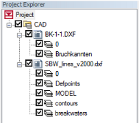
Multiple CAD Files

In response to a New

Also, CAD files are no longer saved when the project is saved. Instead they are treated as externally linked files and only the links are saved.

One other change to CAD file support was the addition of a Properties dialog that shows the CAD file name and path, number of layers, extents, file version, and map projection.

November 2012 Sprint

  • Fixed 8 bugs
  • Released GMS 8.3.7
  • Took GMS 9.0 out of beta. It is now the current version.
  • PHT3D support started
  • MODFLOW-LGR support - major progress
  • Overhauled how framing is done in dev. Framing will be more accurate and the code is much simpler.
  • Separated the registry paths for 32 and 64 bit versions in dev
  • Created two new transient tutorials for dev
  • Wiki -> Help progress
  • Added more bitmaps to pop-up menus in dev
  • Added basic code coverage analysis for GUI tests

PEST Null Space Monte Carlo


GMS supports multiple methods for performing stochastic simulations such as parameter randomization and indicator simulations. In version 9.0 we have added support for another stochastic method: the PEST Null Space Monte Carlo (NSMC) method. The NSMC method allows you to generate multiple calibrated models with different sets of parameters.

There is always a significant amount of uncertainty associated with a groundwater model.  This uncertainty can be associated with the conceptual model or the field data or the input parameters of the model.  Some model parameters, such as hydraulic conductivity, are particularly prone to uncertainty.  This uncertainty can be reduced by calibrating a model to observation data (monitoring wells, stream flows, etc.).  However, even a well-calibrated model can have significant uncertainty associated with it.

The challenge with a groundwater model is to explore the uncertainty while maintaining a calibrated model (good fit with field measured values). The generation of model input parameters that will respect calibration constraints is a time consuming matter since a parameter estimation exercise must be undertaken for each new set of parameters. However, two tools provided with PEST greatly reduce the amount of time required to perform calibration-constrained Monte Carlo analysis of a groundwater model. The first is the use of SVD-Assist in the calibration process. The second is the pre-calibration null space[1]projection of differences between the stochastic parameter fields and the simplified “calibration parameter field” that is decreed to “calibrate the model”. By using both of these utilities it is possible to obtain parameter sets that respect both the stochastic variability of the subsurface as well as the field measured values; this is accomplished with only a handful of runs per realization.

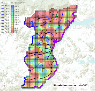
The results from a PEST NSMC run are illustrated in the figures below where we have two different hydraulic conductivity fields and yet the heads at the observations points remain within acceptable error limits.
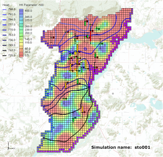
Simulation 1
Simulation 2


Using PEST NSMC is very easy in GMS. Two new tutorials have been developed to teach users how to use the NSMC method in GMS. You can find the tutorials in the GMS Learning Center.


[1] The null space is comprised of individual parameters, or combinations of parameters, that have no effect on model outputs under calibration conditions. These combinations of parameters can therefore be added to any set of parameters which calibrates the model, to produce another set of parameters which also calibrates the model.

October 2012 Sprint

  • Fixed 16 bugs
  • Branched GMS 9.0 code base
  • Held a GMS training course in Australia
  • Initial investigation of MODPATH 6.0 support
  • Added a Z Values -> Data Set command for 2D objects
  • Changed rasters so that interpolation using a raster catalogs results in one data set and interpolation from multiple selected rasters results in multiple data sets
  • Unstructured grids are now rendering in GMS
  • Cleaned up a lot of help links on the wiki and help buttons in GMS
  • Switched scatter points to use the standard Contour Options
  • Added exporting of 3D grids to a VTK file for use in ParaView
  • Progress on support for multiple grids
  • Progress on wiki to dynamic help file

GMS Training - Perth, AU - Recap

We just completed a training course in Perth, Australia from October 23-26. The course was a great success. Users from all over Australia came together to learn how to use GMS to solve their ground water modeling problems. We even had a user fly in from Japan.


Many thanks to our friends at SRIT (Geoff and Glenys Flight) for organizing the course.
SRIT also had a drawing for some prizes for our course attendees.


Rasters

A new image object type which we are calling a "raster" has been added with GMS 9.0. Rasters are essentially images with elevations - an image that includes a color value and a data value at each pixel. GMS uses the raster object type to support DEM files, and a large variety of DEM file types can be imported into GMS as rasters.


Rasters can be displayed as 2D images, with or without shadows, or as a 3D point cloud without shadows. Both options are very fast and memory efficient. Four different shaders, or color ramps, can be used to show  variations in elevation.

Rasters can be interpolated to all other GMS object types as well as to MODFLOW layer data (similar to 2D scatter points). They can be created inside GMS from 2D scatter points.

A wiki page has been created to document the raster interface in GMS and a new Raster tutorial will be available when GMS 9.0 is released.

Online Maps

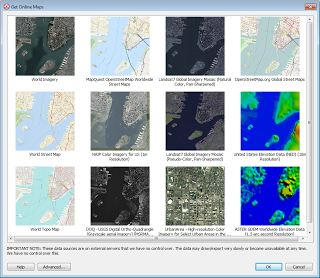
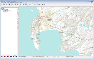
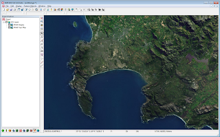
"Online maps" are a new feature added at GMS 9.0. Online maps are free raster data (aerial photos, street maps, elevation data etc.) from sources such as ESRI and OpenStreetMap.org (other sources can be added via an Advanced button). If you have an internet connection, online maps can be displayed in the background in GMS and are updated automatically as you zoom in and out or pan the view. The imagery is automatically projected to the current display projection and displayed in real world coordinates. An online map can be exported and saved locally with your project.

Online maps provide an easy way to locate and start a new modeling project. For more information, see the wiki.

Get Online Maps dialog.

GMS showing a World Topo Map Online Map.

GMS showing a World Imagery Online Map.

September 2012 Sprint Highlights

Some of the more interesting accomplishments from the September 2012 sprint:
  • Fixed over 18 bugs
  • Changed the Virtual Earth Locator tool to start where the graphics windows is currently
  • Project-on-the-fly finished except for tutorial
  • Rasters finished. Added display of elevation under mouse, exporting of more formats, legend fixes, local (non-global) projections, 3D point cloud display
  • Horizons -> Solids using rasters implemented
  • Added node xyz coordinates to arc attribute table
  • Progress on Wiki -> Help
  • GMS 9.0 beta ready
  • MODFLOW-LGR HDF5 conversion done
  • MODFLOW version, precision, parallel options saved in super file

August 2012 Sprint Highlights

Some of the more interesting accomplishments from the August 2012 sprint:
  • Fixed over 14 bugs
  • Fixed dragging display when using computers with integrated graphics 
  • Implemented Project-on-the-fly for all modules and objects
  • Added import/export support for several DEM/Raster file types including:
    • GeoTIFF
    • Arc/Info ASCII Grid
    • BIL
    • USGS DEM
    • FLOAT/GRID (NED)
    • Surfer Ascii Grid Files
    • DXF
  • Added interpolation from raster catalogs
  • Added legends for rasters
  • Added user defined min/max for scatter -> raster
  • Added ability to open multiple files at once
  • Added drag-and-drop to the entire GMS window, not just the Graphics Window
  • Reconfigured the XYZF and IJK/ID panes to accomodate Lat/Lon and projection
  • Added mouse tracking while using the pan and rotate tools
  • Finished some tutorials: null-space Monte Carlo and SUB package

Pages