We use cookies to make your experience better. To comply with the new e-Privacy directive, we need to ask for your consent to set the cookies. Learn more.

Rasters
A new image object type which we are calling a "raster" has been added with GMS 9.0. Rasters are essentially images with elevations - an image that includes a color value and a data value at each pixel. GMS uses the raster object type to support DEM files, and a large variety of DEM file types can be imported into GMS as rasters.

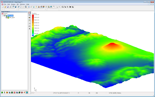
Rasters can be displayed as 2D images, with or without shadows, or as a 3D point cloud without shadows. Both options are very fast and memory efficient. Four different shaders, or color ramps, can be used to show variations in elevation.
Rasters can be interpolated to all other GMS object types as well as to MODFLOW layer data (similar to 2D scatter points). They can be created inside GMS from 2D scatter points.
A wiki page has been created to document the raster interface in GMS and a new Raster tutorial will be available when GMS 9.0 is released.
October 24, 2012
|
View: 1709
|
Categories: GMS
|
By: <a class="mp-info" href="https://aquaveo.com/blog/author/admin">Aquaveo Staff</a>
About the Author

Performing a Silent Install of XMS (Passwords & Hardware Locks)
October 10, 2018
Computing Basin Curve Numbers in 9 Easy Steps
May 16, 2023
Converting a NET File to an INP File
May 9, 2018
Performing a Silent Install for ALS
October 27, 2021
Tips for Finding Information on the XMS Wiki
September 25, 2019
Incorporating MODFLOW 6 Groundwater Energy (GWE)
March 31, 2026
Essential DEM Clean-Up for Watershed Delineation
March 24, 2026
Essential Boundary Condition Guide
March 17, 2026
How to Delineate a Well Capture Zone Using MODPATH
March 10, 2026
How to Decide between Structured or Unstructured Grids
March 3, 2026