GMS

Using Rasters with Map to MODFLOW

For some time GMS has included the capability to use TINs with the Map->MODFLOW command. The next version of GMS will also include the capability to use Rasters with the Map->MODFLOW command similar to how TINs can be used now. In the conceptual model, the user will associate the desired Raster with the Head/Elevation assigned to a point, node, arc, or polygon. When the Map->MODFLOW command is executed the Head/Elevation for the boundary condition is extracted from the Raster using the cell center where the boundary condition is applied. The figure below shows how/where the Raster can be assigned to a point/node/arc/polygon.
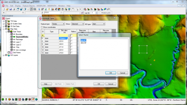
Map to MODFLOW Raster
Blog tags: 

GMS Sprint November 2013

  • Released GMS 9.2
  • Fixed 11 bugs
  • Conducted training in Australia
  • Implemented exporting of faces to CAD
  • Help buttons on wizards now goes to correct wiki or offline help page
  • More progress with improved native MODFLOW text files
  • Good progress on MODFLOW-USG support
  • Help buttons for Qt dialogs no work
  • Tutorial sample files open without prompting for missing file locations
  • Added color and improved readability of model checker dialog
  • Fixed problems with View Previous in ortho mode
Blog tags: 

GMS Sprint October 2013

  • Fixed 3 bugs
  • Branched version 9.2
  • Recorded three new videos for YouTube (not yet posted)
  • Improved test reporting in continuous build machines for MF-2000 and MF-2005
  • Removed copy protection in SEAWAT for GMS 9.1
  • Updated versions of MODFLOW-LGR and MODFLOW-NWT
  • Finished improving native MODFLOW text format for areal parameters
  • Completed design of CLN process interface
  • Created a 1D array editor dialog for MODFLOW-USG similar to 2D version
  • Got list package dialogs working for MODFLOW-USG
  • Fixed it so that 3D grids and Ugrid versions of MODFLOW can coexist
  • Got Sources/Sinks dialog working for MODFLOW-USG
  • Got LAK package dialog working for MODFLOW-USG
  • Got SUB package dialog working for MODFLOW-USG
  • Got CCF view values working for MODFLOW-USG
  • Got ZONEBUDGET working for MODLFOW-USG
  • Began conversion to Qt
  • Did some investigations of SWIG
  • Got Ugrid data sets working (import/export, save/restore, data calculator)
  • Saving Ugrid in VTK format in project (.gpr) file
Blog tags: 

September 2013 Sprint

  • PEMEX conference
  • LA County training
  • Fixed 5 bugs
  • MODFLOW-USG progress including:
    • Convert 3D grid to USG
    • STR package I/O
    • GAG package I/O
    • Read solution including head, drawdown, and CCF files
    • RCH and EVT package dialogs
    • Selecting USG cells
    • Displaying symbols in USG
  • MODFLOW text output progress including:
    • ETS, EVT, GAGE, LAK, MNW, OBS, RCH, SFR, STR, SUB, and UZF packages
  • Import MODFLOW well package data from text files
  • Updated to latest version of MF2K5
  • Pathlines -> Arcs command now works without capture zones
  • GeoPDF tests added
  • Branched version 9.2
Blog tags: 

Pages