Tips for Managing Cross Sections in WMS
Cross sections are commonly used in 1D models within WMS. Here we discuss a few things to help you better model using cross sections.
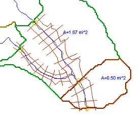
When you create cross sections in WMS, you must create them on "1D-Hyd Cross Section" coverage. You then create the arcs on this coverage to represent the cross sections.There are a few things you should remember when setting up your cross sections:
- Cross sections should be located at fairly frequent intervals along the river. This makes sure the characterization of the stream channel and floodplain flow and capacity is accurate, which gives you better results.
- You should place cross sections especially at locations of significant change, where levees begin and end, at hydraulic structures, and around stream junctions.
- The cross section arcs should generally stretch from one side of the river floodplain to the other.
- They should be generally perpendicular to the river arc where they cross.
- Cross section arcs should not cross each other.

In addition to the above, each cross section should have the following required information:
- River name
- Reach name
- River station
- Description
- Station–elevation data
- Downstream reach lengths
- Manning’s n values
- Main channel bank stations
- Contraction and expansion coefficients
It is recommended that the station number be visible on the map view to make the cross sections more identifiable. This can be enabled in the Display Options dialog. When numbering stations, they must be in ascending numerical order from downstream to upstream. If changes are made, be sure to renumber the stations.
Converting an arc into a cross section arc can be done automatically or manually. You can automatically do it by taking the following steps:
- Define or import a TIN.
- Create an area property coverage, a centerline coverage, and a 1D-Hyd cross section coverage.
- Use the Extract Cross Section command to extrude the cross sections from the 2D arcs.
To manually create a cross section arc:
- Double-click on the cross section arc and select Assign Cross Section.
- Define the various elevations and data as desired.
Try out these tips and procedures today in the WMS Community Edition!


