We use cookies to make your experience better. To comply with the new e-Privacy directive, we need to ask for your consent to set the cookies. Learn more.

Best Practices for Modeling Complex Geometries
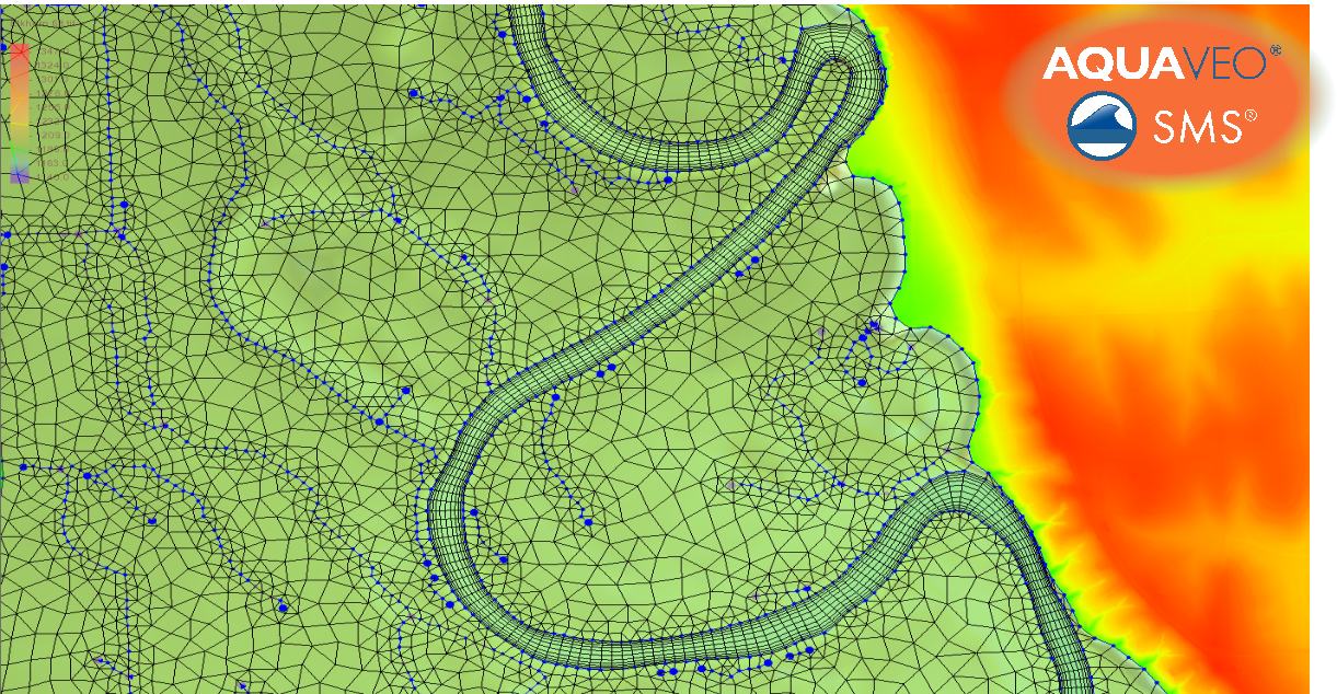
Building an accurate hydraulic model starts before generating a computational mesh or grid. In the Surface-water Modeling System (SMS), modelers typically begin by creating coverages, which contain feature objects such as arcs, nodes, and polygons. These feature objects define the conceptual layout of the model and are later converted into computational geometry such as a mesh or grid. Because the mesh generation process depends heavily on these inputs, investing time in carefully constructing coverages is essential for producing stable and accurate simulations.
Best Practices for Using Coverages to Model Complex Geometries in SMS
SMS supports multiple distinct numerical engines (e.g., SRH-2D, ADCIRC, TUFLOW FV). The specific rules for drawing coverages and generating meshes depend on the selected engine. For instance, SRH-2D workflows heavily utilize quadrilateral patches, which require different vertex distribution strategies (often requiring mirrored vertex counts on opposing arcs) compared to the purely unstructured triangular meshes utilized by ADCIRC.
There are, however, best practices that apply across all engines.
Understand the Role of Coverages in SMS
Coverages act as the conceptual modeling layer in SMS. Instead of editing the computational geometry directly, users first draw feature objects—arcs to represent boundaries or breaklines, nodes for key locations, polygons for material zones or refinement regions, etc. These objects guide how the mesh or grid is generated.
Well-prepared coverages help ensure that the resulting computational geometry aligns with important physical features in the model domain.
Redistribute Vertices for Better Geometry Control
One common issue when drawing arcs is uneven spacing between vertices. If vertices are clustered in some locations and sparse in others, the resulting mesh may contain distorted elements or poor alignment.
SMS provides tools that allow users to redistribute vertices along arcs, creating evenly spaced points along a feature. This is particularly useful for long channel banks, levees, or shoreline boundaries where consistent geometry helps produce smoother mesh transitions.
Redistributing vertices helps maintain a balanced representation of the geometry without introducing unnecessary complexity.
Use Higher Geometry Density Where It Matters
While evenly spaced vertices are helpful, some areas require more detailed geometry. Tight channel bends, confluences, hydraulic structures, or sudden terrain transitions often need additional vertices so arcs can follow the landscape accurately.
In these areas, increasing vertex density allows the mesh to better capture flow patterns and hydraulic gradients. However, modelers should avoid adding excessive detail in areas where the terrain is relatively uniform, as this can increase computational cost without improving results.
Pay Close Attention to Topographic Data
Topographic datasets such as digital elevation models (DEMs), contour maps, or surveyed cross sections should guide how arcs and polygons are drawn. Carefully reviewing terrain data within SMS helps identify key features such as channel banks, ridges, and floodplain boundaries.
Drawing arcs that follow these natural features ensures the resulting mesh reflects the true hydraulic pathways of the system.
Consider Elevation Changes
Elevation differences can have a significant impact on flow behavior. When defining coverages, modelers should consider how terrain elevations influence flow paths, barriers, and water storage areas.
For example, arcs representing levees, embankments, or channel banks should closely follow elevation changes visible in the terrain data. Doing so ensures that the mesh honors important hydraulic controls during simulation.
Build Clean and Functional Geometry
Finally, ensure that arcs connect properly at nodes and that polygons form closed boundaries when defining areas. Clean topology prevents errors during mesh generation and helps maintain a well-organized conceptual model.
Conclusion
Creating high-quality coverages in SMS requires careful attention to geometry, vertex spacing, terrain features, and elevation data. By taking the time to thoughtfully draw arcs and polygons before converting them into a mesh or grid, modelers can build computational geometries that are more stable, efficient, and hydraulically accurate.
Download SMS now and take advantage of coverages to enhance the accuracy of your projects.
April 28, 2026
|
View: 1108
|
Categories: SMS
|
By: <a class="mp-info" href="https://aquaveo.com/blog/author/admin">Aquaveo Staff</a>
About the Author

Performing a Silent Install of XMS (Passwords & Hardware Locks)
October 10, 2018
Converting a NET File to an INP File
May 9, 2018
Computing Basin Curve Numbers in 9 Easy Steps
May 16, 2023
Performing a Silent Install for ALS
October 27, 2021
Tips for Finding Information on the XMS Wiki
September 25, 2019
Tips for Using Wells with MODFLOW 6
July 14, 2026
Enhanced Arc Geometry and Vertex Tools
July 7, 2026
SRH-2D Inflow & Outflow Best Practices
June 30, 2026
Troubleshooting Projection and Coordinate System Issues
June 23, 2026