We use cookies to make your experience better. To comply with the new e-Privacy directive, we need to ask for your consent to set the cookies. Learn more.

Filling Missing Raster Data
Do you have a raster that has holes in it? The Fill Nodata can fix small holes in raster data. Available in GMS, SMS, and WMS. In this article, we will explore the ways that the Fill Nodata tool can be used in WMS.
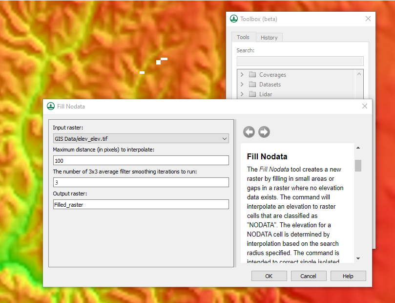
The Fill Nodata tool fills in small areas or gaps in a raster where no elevation data exists. It is located in the Rasters/Fill Nodata section of the Toolbox. The tool will interpolate an elevation to raster cells that are classified as "NODATA". Then the tool will create a new raster in the project that has the fillable no data areas filled.
These holes in the raster can occur for a number of reasons, one of the most common being that the data is incomplete. WMS is flexible enough that it can use a raster with small amounts of missing data for most simulations. However, it is recommended that you have data that is as complete as possible to ensure the generated model is as accurate. Therefore using the Fill Nodata tool can help ensure the accuracy of your model.
The Fill Nodata tool has a few input parameters to keep in mind. The input raster is the most important parameter. This needs to be a raster that has been imported into the project. The maximum distance to interpolate determines how far out WMS will look to fill data. It will use pixel units to do this. The number of 3x3 average filter smoothing iterations to run determines how many smoothing interactions will be run after the interpolation has been calculated. Additional interactions can help in improving the fill data.
Keep in mind that the tool was not intended to create data for large regions of missing data cells, especially regions on the border of the raster. If you have a large area of missing data, it would be best to use other processes to fill in the missing data, such as downloading the missing data and merging it with your raster.
The Fill Nodata tool is one of thetools provided in WMS to let you modify and edit raster data. Try out the Fill Nodata tool in WMS today!
About the Author

Performing a Silent Install of XMS (Passwords & Hardware Locks)
October 10, 2018
Computing Basin Curve Numbers in 9 Easy Steps
May 16, 2023
Converting a NET File to an INP File
May 9, 2018
Performing a Silent Install for ALS
October 27, 2021
Tips for Finding Information on the XMS Wiki
September 25, 2019
Comparing Multiple Design Alternatives in One Project
April 7, 2026
Incorporating MODFLOW 6 Groundwater Energy (GWE)
March 31, 2026
Essential DEM Clean-Up for Watershed Delineation
March 24, 2026
Essential Boundary Condition Guide
March 17, 2026
How to Delineate a Well Capture Zone Using MODPATH
March 10, 2026