We use cookies to make your experience better. To comply with the new e-Privacy directive, we need to ask for your consent to set the cookies. Learn more.

Simplify Watershed Analysis with the Centroids from Polygons Tool
Introduced in the latest version of the Watershed Modeling System (WMS), the Centroids from Polygons Tool is one of many new tools to help you simplify watershed analysis. This tool offers a streamlined way to generate centroid points from vector polygon or polyline data. This can provide a useful reference for anyone working on watershed delineation or spatial analysis in hydrologic models.
Centroids are central points that represent the spatial “center of mass” of a shape. When applied to watershed modeling, these points can serve a variety of purposes. They are often used as reference markers, labeling locations, or input points for further geospatial processing. For instance, in a watershed with multiple sub-basins, centroids can help define the location of key features such as rainfall gages, outlets, or control structures.
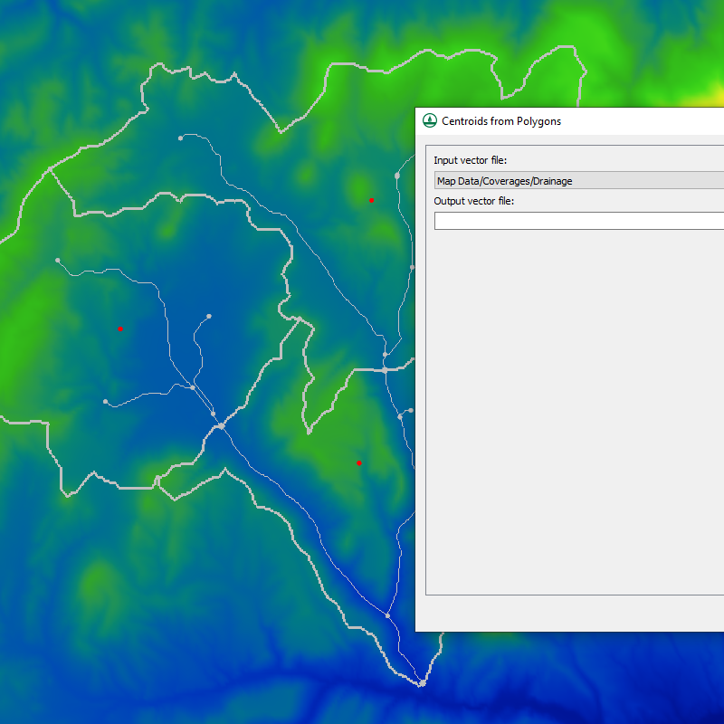
The Centroids from Polygons Tool takes in a coverage containing polygons and generates a new coverage containing centroid points. The tool is located under the Toolbox, Coverages > Centroids from Polygons menu, making it easy to integrate into your existing workflow.
Built on the WhiteboxTools open-source GIS library, this tool brings reliable and flexible functionality. One particularly useful feature is how it handles multi-part vector features. By default, it treats a multi-part polygon or polyline as a single entity, calculating one centroid for the entire shape. This simplifies the data and keeps your model uncluttered. However, future enhancements may allow you to choose whether to calculate centroids for each part individually.
Whether you’re identifying sub-basin centers, preparing input points for hydrologic or hydraulic modeling, or simply improving the visualization of your watershed, the Centroids from Polygons Tool saves time and improves accuracy. It's a small but powerful addition to the WMS toolbox.
For full details, visit the tool in WMS under Coverages | Centroids from Polygons. This new tool simplifies locating central locations in watersheds. Try out this new tool in your next watershed project in WMS today!
May 27, 2025
|
View: 4170
|
Categories: WMS
|
By: <a class="mp-info" href="https://aquaveo.com/blog/author/admin">Aquaveo Staff</a>
About the Author

Performing a Silent Install of XMS (Passwords & Hardware Locks)
October 10, 2018
Converting a NET File to an INP File
May 9, 2018
Computing Basin Curve Numbers in 9 Easy Steps
May 16, 2023
Performing a Silent Install for ALS
October 27, 2021
Tips for Finding Information on the XMS Wiki
September 25, 2019
Tips for Using Wells with MODFLOW 6
July 14, 2026
Enhanced Arc Geometry and Vertex Tools
July 7, 2026
SRH-2D Inflow & Outflow Best Practices
June 30, 2026
Troubleshooting Projection and Coordinate System Issues
June 23, 2026