We use cookies to make your experience better. To comply with the new e-Privacy directive, we need to ask for your consent to set the cookies. Learn more.
Using BCDATA Lines with SRH-2D
Have you needed to modify how SRH-2D calculates flow around a structure? Using BCDATA lines in SMS may be able to help. New to SMS 13.1, the BCDATA line feature lets you specify a location where a water level or flow rate is extracted for a variable boundary condition.
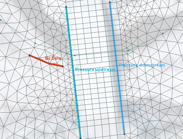
The BCDATA line is primarily used to adjust how flow is calculated going into or leaving a structure. If there is high skew or rapid drawdown at the entry or exit of the structure then you should consider using a BC Data line. It indicates that rather than performing flow computations directly at the site of the structure, they should be performed at the location of the BCDATA line.
There are a few applications for a BCDATA line. For instance, it can be used on a structure such as a weir or culvert. When SRH-2D computes flow through or over a structure, it uses an average water surface elevation. When no BCDATA line is present, SRH-2D computes right along the nodes where the upstream boundary condition arc has been mapped. If an upstream or downstream BCDATA line exists, the water level can be computed there rather than at the actual edges of the structure. The BCDATA line should typically be located one or two cells upstream or downstream from the structure to get out of the zone of influence of the structure itself. This avoids drawdown caused by the flow going through or over the structure.
To create a BCDATA line and assign it to a structure, use the following workflow:
- Use the Create Feature Arc tool to create a line a few elements long, ideally about 1 to 2 elements away from the upstream or downstream arc. Create it perpendicular to the arc and along the centerline.
- Using the Select Feature Arc tool, select the line you have just created, right-click it, and select Assign BC… to bring up the SRH2D Assign BC dialog.
- Set the BC Type to Bc Data. Make sure to provide a label name that is unique in the coverage. Then click OK to close the dialog.
- Now select the upstream or downstream arc that is meant to be associated with the BCDATA line, right-click it, and select Assign BC… to bring up the SRH2D Assign BC dialog.
- Scroll down to the General structure options section at the bottom. Depending on whether the arc selected is upstream or downstream, check the box by the appropriate BCDATA line option.
- Use the drop-down that populates to select the label you previously specified for the BCDATA line. Then click OK to close the dialog.
The BCDATA line will now be assigned to the structure.

It can also be used on a Link or an EXIT-H boundary condition that you have specified using a rating curve. Normally, without a BCDATA line, SRH-2D computes the average flow directly at the line and then extracts the water level from the curve. When a BCDATA line does exist, the flow rate (Q) is computed across the BCDATA line, like a monitor line, rather than exactly at the boundaries.
Try using BCDATA lines with SRH-2D in SMS 13.1 today!


