We use cookies to make your experience better. To comply with the new e-Privacy directive, we need to ask for your consent to set the cookies. Learn more.
How to Refine a Mesh Around Structures Using the Map Module
Accurate surface-water modeling requires precise representation of critical hydraulic structures, including bridges, levees, culverts, and weirs. Even small features in some projects can dramatically alter flow patterns, water surface elevation, and flood routing. The technical challenge is generating a high-quality, refined mesh around these structures without resorting to time-consuming manual edits after generation.
The most effective approach is to define element size and shape controls before mesh creation, using the Map module in the Surface-water Modeling System (SMS). By applying a few simple best practices in the Map Module, you can ensure the mesh conforms accurately to critical structure boundaries, placing the necessary high resolution exactly where flow behavior changes rapidly.
Best Practice #1: Digitize Your Structures with Arcs and Polygons
Before mesh generation, trace every important structural feature using arcs and polygons in the Map module.
Rule of thumb: If it can change flow direction or speed, digitize it:
-
Bridge piers and road decks
-
Channel constrictions and embankments
-
Levees and floodwalls
-
Culverts and weirs
These feature objects act like drawing instructions for the mesh. When SMS builds the mesh, it follows your lines, creating sharper boundaries and higher accuracy at critical flow changes.
Action: Digitize structural features like bridge piers, embankments, road decks, and channel constrictions by creating arcs or polygons in the Map Module.

Best Practice #2: Redistribute Vertices at Critical Flow Zones
Not all features need the same level of detail.
Rule of thumb: Focus refinement where water accelerates, squeezes, or changes direction, especially near:
-
Sharp angles
-
Narrow passages
-
Steep gradients
-
Structural boundaries
Use the Redistribute Vertices function on arcs to tighten spacing near the structure and relax spacing where flow is slower or uniform. This targets resolution exactly where it’s needed—without bogging down the whole model.
Action: Use the Redistribute Vertices command on your structure arcs. Apply smaller spacing near critical details—like a river bend or the upstream side of a bridge pier—where flow changes direction or accelerates rapidly (high gradients). Use larger spacing along less critical, straight sections.
Best Practice #3: Use Size Polygons for Smooth Transitions
For complex simulations, add size polygons to control element size around structures or smooth transitions between the structures and the rest of the mesh.
Rule of thumb: Create:
-
Fine mesh close to the feature
-
Coarser mesh farther away
-
Smooth transitions that prevent solver instability
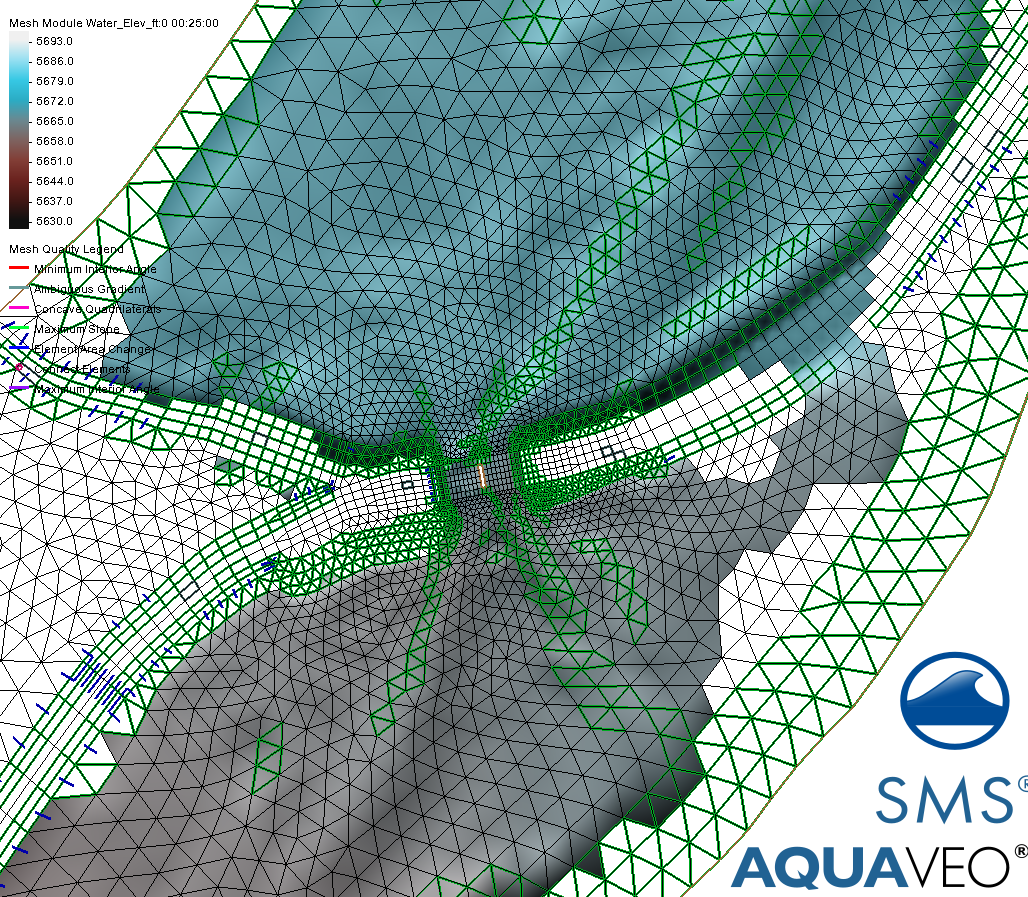
Action: Assign size polygons around complex structures. This ensures finer elements are generated near the structure for accuracy, and gradually transition to coarser elements further away. This controlled transition is vital for maintaining solver stability and avoiding computational crashes.
Mesh Quality Checkup
Once your geometry, breaklines, and size controls are set in the Map Module, the SMS mesh engine will honor these rules to produce a clean, refined mesh. Save your work and generate the mesh.
Rule of thumb: After generation, always check the mesh quality. Look for warning signs like skewed elements (triangles that are too thin or misshapen) or excessive node crowding. If you've used the Map Module strategies above, these issues should be minimal.
Refining Meshes around Structures
By refining in the Map module, you get:
-
Better boundary alignment
-
Higher numerical stability
-
Faster solver performance
-
Less cleanup later
High-Quality Hydraulic Modeling starts with a high-quality mesh. Master these three Map Module practices, and you'll dramatically improve your model mesh accuracy and save hours of downstream repair work. Download SMS today and take advantage of the mesh refinement options for your surface-water models.


