We use cookies to make your experience better. To comply with the new e-Privacy directive, we need to ask for your consent to set the cookies. Learn more.

Connecting UGrid Points with Arcs
Whether you’re working with survey data, a mesh, or an unstructured grid (UGrid), for many projects understanding how your points spatially relate to each other can be essential for ensuring model precision and performance. In the Surface-water Modeling System (SMS), the Arcs from UGrid Points tool provides a simple solution for automatically connecting the points in your model by generating arcs along the lines of your grid.
This tool allows you to take your existing data and transform it into a new coverage of connecting arcs. It’s especially useful for creating boundary conditions, structures, monitoring lines, and more. And while the tool works with various grid types, it’s important to note that this tool is designed to work with 2D grids rather than 3D grids.
How to Connect Your Points
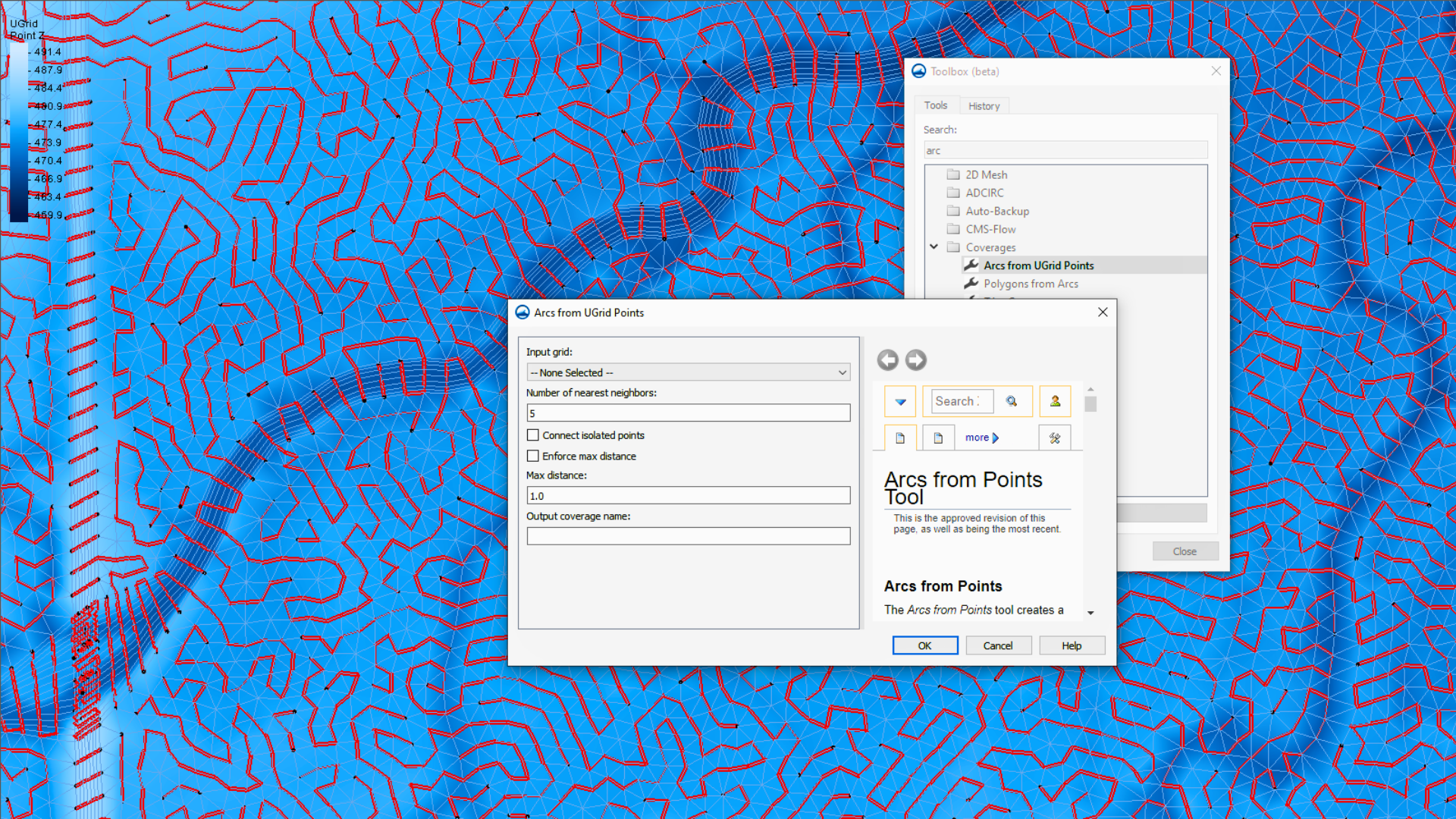
The Arcs from UGrid Points tool works by examining the spatial proximity of your input points. You can find this tool by navigating to the Toolbox dialog and looking under the “Coverages” folder.
For the fields in the Arcs from UGrid Points dialog, the only necessary component is designating which geometric coverage you’ll select for the Input grid drop-down menu. For this option, you must pick the coverage that contains the points you wish to connect with the arcs. This might include scatter sets, 2D mesh, or UGrids. Ensure the coverage you select includes only the points that are relevant to the connections you want to make; the tool will analyze and attempt to connect all eligible points within the selected coverage. If your coverage contains a mix of different feature types (nodes, cells, etc.), double-check that only the points are selected or use a filtered coverage to avoid unintended connections.
The rest of the fields in the Arcs from UGrid Points dialog are optional:
-
Number of nearest neighbors: Specify how many nearby points to consider when connecting points. A lower number helps the tool run faster, while a higher number can identify more potential connections.
-
Connect isolated points: Attempts to connect outlying points to the closest arc after the main arc is created. This is disabled by default and not recommended for general use.
-
Enforce max distance: Sets a maximum connection distance. If enabled, only neighboring points within the specified distance connect.
-
Max distance: Required if “Enforce max distance” is selected. This sets the maximum distance allowed for connecting points.
The Arcs from UGrid Points tool will then build arcs by starting with the closest points and finding neighboring points that are closest to each other, respecting the parameters you’ve defined.
Using Arcs to Build Your Model
This tool is a valuable step in organizing your point data by transforming scattered point data into a network of connected arcs. These new arcs reside in their own coverage, becoming the building blocks for many more model features. For example, you can use this tool to take survey points and use the generated arcs to define boundary conditions for your simulation. Similarly, you could represent linear structures or establish a framework of monitoring lines based on the connections established by this tool. It can also be used to troubleshot issues with imported data.
By turning raw data and scatter points into usable coverages, the Arcs from UGrid Points tool can help you center your modeling process and improve overall simulation setup. It’s a simple but powerful way to bring structure, ease, and clarity to your SMS projects.
Ready to optimize your SMS projects and see how the Arcs from UGrid Points tool can help you build your model? Download SMS 13.4 today!
May 6, 2025
|
View: 4513
|
Categories: SMS
|
By: <a class="mp-info" href="https://aquaveo.com/blog/author/admin">Aquaveo Staff</a>
About the Author

Performing a Silent Install of XMS (Passwords & Hardware Locks)
October 10, 2018
Converting a NET File to an INP File
May 9, 2018
Computing Basin Curve Numbers in 9 Easy Steps
May 16, 2023
Performing a Silent Install for ALS
October 27, 2021
Tips for Finding Information on the XMS Wiki
September 25, 2019
Tips for Using Wells with MODFLOW 6
July 14, 2026
Enhanced Arc Geometry and Vertex Tools
July 7, 2026
SRH-2D Inflow & Outflow Best Practices
June 30, 2026
Troubleshooting Projection and Coordinate System Issues
June 23, 2026