We use cookies to make your experience better. To comply with the new e-Privacy directive, we need to ask for your consent to set the cookies. Learn more.

Applying Hard Bottom Data to Your CMS Simulations
Could your Coastal Modeling System (CMS) project in the Surface-water Modeling System (SMS) use a hard bottom dataset? Including a hard bottom dataset can improve the modeling of the seabed conditions where there are non-erodible surfaces. To make it easier to obtain this dataset, the CMS-Flow Hard Bottom Dataset Tool has been added to SMS. Here’s how you can leverage this tool in the Surface-water Modeling System (SMS) to enhance your modeling projects.
What Is the CMS-Flow Hard Bottom Data Tool?
CMS-Flow Hard Bottom Dataset is a tool that is used in conjunction with a hard bottom coverage for CMS-Flow, where you can assign different types of polygons to the UGrid to create the hard bottom dataset. This allows for detailed control over which areas are erodible and to what extent.
Here are the polygon types you can assign:
-
Non-erodible cells: The cell elevation sets the hard bottom dataset value, which stops erosion in that area.
-
Specified distance erodible cells: The hard bottom dataset value is found by taking the cell elevation and subtracting the specific distance linked to the polygon. For instance, given a cell elevation of 5.5 and an erodible distance of 2.0, the resulting hard bottom value would be 3.5.
-
Specified depth erodible cells: The given depth value, which is linked with the polygon, is represented as an elevation (Z) and assigned to the hard bottom dataset.
-
Fully erodible cells: Cells that aren’t covered by the polygon types mentioned above are considered fully erodible.
Using CMS-Flow Hard Bottom Dataset
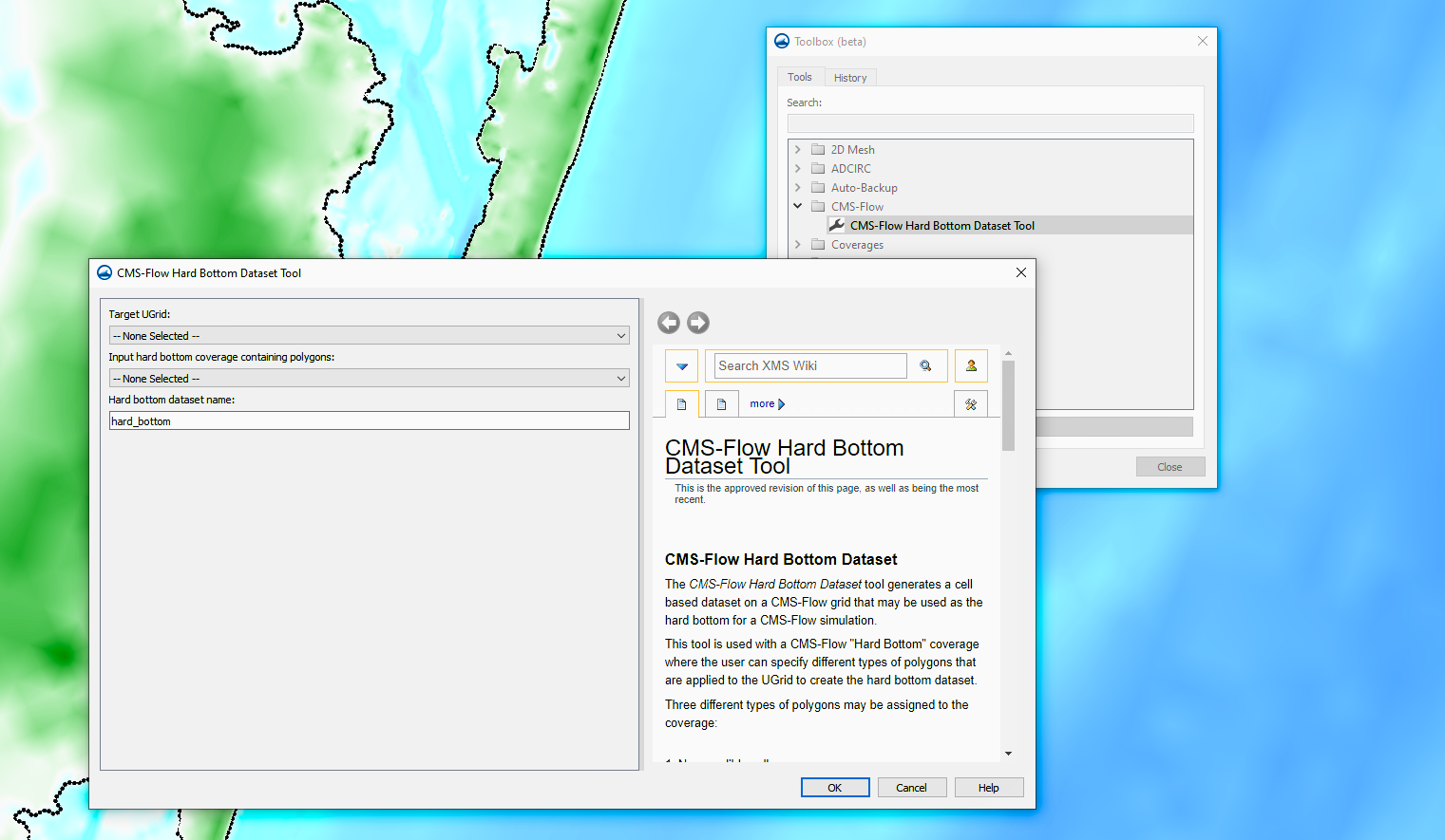
You can find the CMS-Flow Hard Bottom Dataset Tool in the Toolbox under CMS-Flow. Here, you’re able to specify areas within your model where erosion is restricted. Specifying a hard bottom helps to better isolate the variables being tested, which allows for more accurate results.
To use the CMS-Flow Hard Bottom Dataset Tool, you’ll need to set a few input parameters:
-
Target UGrid: The UGrid used in the CMS-Flow simulation requires that cell elevations are defined.
-
Input hard bottom coverage containing polygons: This coverage defines the hard bottom polygons.
You’ll also need to set the Hard bottom dataset name, which will define the name of your output dataset for easy identification.
By using the CMS-Flow Hard Bottom Dataset Tool, you can significantly improve the accuracy and reliability of your coastal simulations. This tool is able to provide the precision and control needed to effectively model complex hard bottom regions, leading to more insightful and robust results. By incorporating hard bottom datasets into your CMS-Flow workflow, you can make sure that your simulations better reflect real-world seafloor conditions and function in the way you need them to for your projects.
Download SMS and make use of hard bottom data for your CMS simulation today!
March 25, 2025
|
View: 4290
|
Categories: SMS
|
By: <a class="mp-info" href="https://aquaveo.com/blog/author/admin">Aquaveo Staff</a>
About the Author

Performing a Silent Install of XMS (Passwords & Hardware Locks)
October 10, 2018
Computing Basin Curve Numbers in 9 Easy Steps
May 16, 2023
Converting a NET File to an INP File
May 9, 2018
Performing a Silent Install for ALS
October 27, 2021
Tips for Finding Information on the XMS Wiki
September 25, 2019
SMS 13.5 Beta Out Now!
May 26, 2026
Tips for Modeling Bridge Scour
May 19, 2026
Essential Guide to WMS Rain-on-Grid Modeling
May 5, 2026
Best Practices for Modeling Complex Geometries
April 28, 2026