We use cookies to make your experience better. To comply with the new e-Privacy directive, we need to ask for your consent to set the cookies. Learn more.

Curve Number Values for NLCD Land Use Data
Are you wondering what values to use for composite curve numbers used with NLCD land use data in your WMS project? WMS contains a Compute GIS Attributes calculator in the Hydrologic Modeling Module that allows you to import composite curve numbers to use in land use mapping. This can allow you to define boundaries for different soils, rainfall depths, etc. This post will cover some different resources to get the values you need.
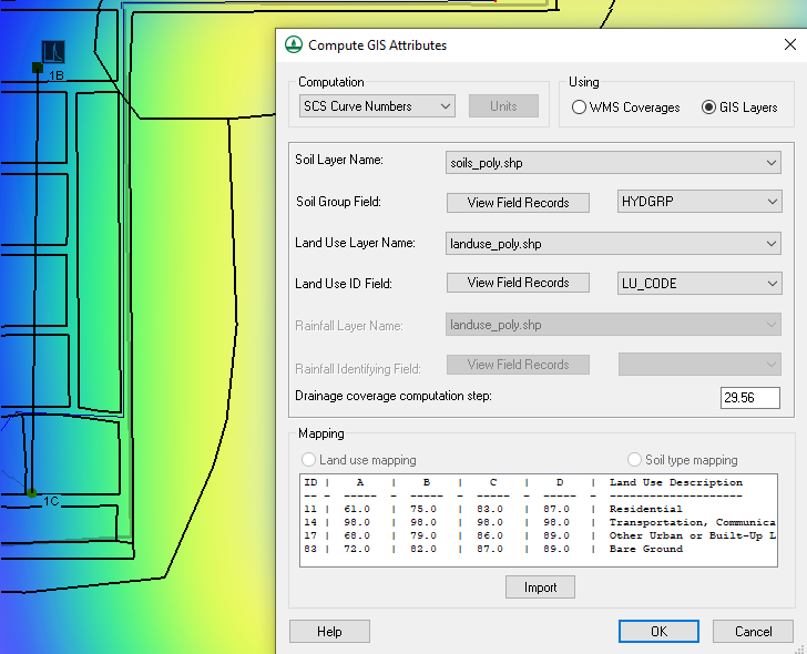
It is important to be aware that there are two options when using the Computing GIS Attributes calculator: WMS Coverages as well as GIS Layers. With both GIS Layers and WMS Coverages you are given the option of selecting the Soil Layer Name, Drainage coverage computation step, etc. In the GIS Layers you are given the option to view field records and assign a code of your choosing. To use the GIS Layers option, you will need to have already imported GIS data into your project. In order to make the WMS Coverages option active you will need to have created your own land use or soil type coverages within WMS. Using the WMS Coverage option allows you to import your own land use or soil curve numbers from a text file.
What values you use for the text file depends on your own judgment and what would work best for your project. One option to get the table values is to use the example files found on XMS Wiki in the SCS Curve Numbers section. Opening one of these examples will show you an area-weighted average of the different curve numbers for the different regions. Another option is to visit the USGS website, download the example data, and import it into the GIS Attributes dialog. Finally, you can make your own table In which case use your engineering judgment to determine the CN values for your project.
Try out inserting curve number values for NLCD land use data in WMS today!
June 15, 2022
|
View: 4084
|
Categories: WMS
|
By: <a class="mp-info" href="https://aquaveo.com/blog/author/admin">Aquaveo Staff</a>
About the Author

Performing a Silent Install of XMS (Passwords & Hardware Locks)
October 10, 2018
Computing Basin Curve Numbers in 9 Easy Steps
May 16, 2023
Converting a NET File to an INP File
May 9, 2018
Performing a Silent Install for ALS
October 27, 2021
Tips for Finding Information on the XMS Wiki
September 25, 2019
How to Delineate a Well Capture Zone Using MODPATH
March 10, 2026
How to Decide between Structured or Unstructured Grids
March 3, 2026
Storing Time Series Data Using the Spatial Data Coverage
February 24, 2026
Perfect Realistic Conceptual Groundwater Models
February 17, 2026
WMS 11.4: Now Out In Beta
February 10, 2026