We use cookies to make your experience better. To comply with the new e-Privacy directive, we need to ask for your consent to set the cookies. Learn more.

Mapping Multiple Coverages in GMS
Do you have a conceptual model project in GMS where you have multiple map coverages with values for the same MODFLOW package? Are you wondering how GMS maps values from multiple coverages over to the MODFLOW packages?
It's not unusual for some projects to require the same attributes to be in separate coverages rather than having all the attributes in a single coverage. For example you might want to use recharge attributes from different sources and have placed the values on different coverages. But how exactly does GMS handle this? This post should hopefully give you a better sense of what GMS is doing behind the scenes.
Normally, the values for a particular MODFLOW package, such as recharge, are placed on one coverage that uses multiple polygons. In this case, a single value can be calculated, taken only from the predominant polygon, as it is expected that the polygons will all be within the same coverage. Also in this case, the methodology is designed to accommodate polygons being used to calibrate recharge zones in PEST, as opposed to calibrating with pilot points. If using gradient recharges, it is recommended to use scatter points to interpolate recharge values to MODFLOW layers.
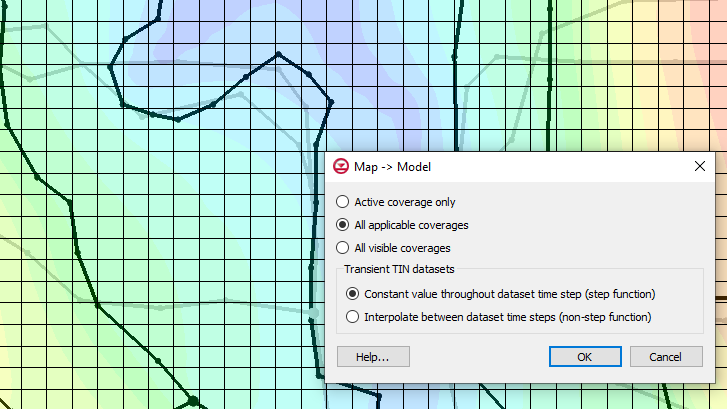
You may have a case where you have the values for a package, such as recharge, on polygons on different map coverages. This could be because you imported the values from different sources. In cases where the polygons on different map coverage overlap, the attribute types with different values will have those values summed up when they are applied all at once if you map all of the coverages at the same time. If you don’t want them summed up, make sure that rather than applying them all at once, the value you want is the last value mapped over. This is because when multiple coverages are applied at once, GMS sum the values cumulatively, but when done individually, GMS overwrites the value with the most recently mapped coverage.
It is important to note that hydraulic conductivity is not cumulative, though the sources may be. Hydraulic conductivity is overwritten every time, so the values MODFLOW receives are the values of the last polygon that intersected an individual cell.
Items in the Project Explorer are mapped in descending order, so changing the order of the coverages can change the end results.
You can also find more information on how objects are mapped to MODFLOW at the Aquaveo XMS Wiki.
Try mapping multiple coverages in GMS 10.5 today!
July 21, 2021
|
View: 2083
|
Categories: GMS
|
By: <a class="mp-info" href="https://aquaveo.com/blog/author/admin">Aquaveo Staff</a>
About the Author

Performing a Silent Install of XMS (Passwords & Hardware Locks)
October 10, 2018
Computing Basin Curve Numbers in 9 Easy Steps
May 16, 2023
Converting a NET File to an INP File
May 9, 2018
Performing a Silent Install for ALS
October 27, 2021
Tips for Finding Information on the XMS Wiki
September 25, 2019
How to Delineate a Well Capture Zone Using MODPATH
March 10, 2026
How to Decide between Structured or Unstructured Grids
March 3, 2026
Storing Time Series Data Using the Spatial Data Coverage
February 24, 2026
Perfect Realistic Conceptual Groundwater Models
February 17, 2026
WMS 11.4: Now Out In Beta
February 10, 2026