We use cookies to make your experience better. To comply with the new e-Privacy directive, we need to ask for your consent to set the cookies. Learn more.

Using Shapefiles for Stream Arcs in WMS
Shapefiles contain valuable data that can be used for modeling in WMS. If you have an existing shapefile that has arcs that define the streams for the area you will be modeling, you can use that shapefile to define the streams in your WMS project. Doing this can save you from manually having to define the stream arcs manually.
Do use a shapefile for stream arcs in WMS, do the following:
- Import or download the shapefile into WMS. The file data will appear in the GIS module. Review the arcs to make certain they align with the stream location.
- With the shapefile active, use the Mapping | Shapes to Feature Objects command.
- In the GIS to Feature Objects Wizard, map the shapefile to the drainage coverage. If you are using another coverage besides the drain coverage make certain to select the correct coverage in the first step of the wizard.
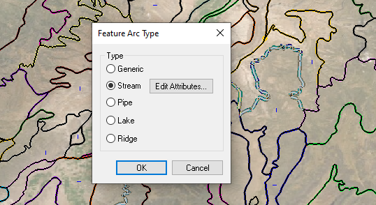
- After mapping the arcs to the drainage coverage, use the Select Feature Arc tool to select arcs along each stream.
- Right-click and select the Attributes command to open the Attributes dialog for the selected arcs.
- Change the attributes of the arcs to be Streams.
After creating the stream arcs, it is recommended that you review the streams to make certain the streams going in the right direction. Use the display option to see the stream arc direction and use the Reverse Direction command to change the direction of arcs.
It is also recommended that you carefully review the arcs that were mapped over to the drainage coverage. Delete any unnecessary arcs and clean up the arcs to improve the performance of the model. It is recommended that stream arcs be merged together except in locations where they branch or where a subbasin is meant to start. Merge arcs by changing a node to a vertex.
Shapefiles can help you build your watershed project in WMS quickly Try out creating stream arcs from shapefiles in WMS today!
February 17, 2021
|
View: 2747
|
Categories: WMS
|
By: <a class="mp-info" href="https://aquaveo.com/blog/author/admin">Aquaveo Staff</a>
About the Author

Performing a Silent Install of XMS (Passwords & Hardware Locks)
October 10, 2018
Converting a NET File to an INP File
May 9, 2018
Computing Basin Curve Numbers in 9 Easy Steps
May 16, 2023
Performing a Silent Install for ALS
October 27, 2021
Tips for Finding Information on the XMS Wiki
September 25, 2019
Diagnosing Costly Model Stability Issues
June 9, 2026
New Display Enhancements in GMS 10.9
June 2, 2026
SMS 13.5 Beta Out Now!
May 26, 2026
Tips for Modeling Bridge Scour
May 19, 2026