We use cookies to make your experience better. To comply with the new e-Privacy directive, we need to ask for your consent to set the cookies. Learn more.

Visualizing Groundwater Flow Paths and Travel Time with Clarity
Groundwater modeling often answers how much water moves, but not always where it goes or how long it takes to get there. However, when groundwater decisions carry regulatory, financial, and environmental consequences, uncertainty isn’t an option. For water-supply protection, contaminant investigations, and remediation planning, those unanswered questions can introduce real risk. Groundwater Modeling System (GMS) makes these critical insights visible by combining MODFLOW results with integrated MODPATH particle tracking, turning complex data into actionable understanding.
So how do you move from numerical model output to insight you can see, trust, and explain? It starts with visualization in GMS.
Step 1: Build and Run a Calibrated Flow Model
Clear visualization and a reliable flow-path analysis starts with a strong foundation. In GMS, the first step toward defensible flow paths and travel times is developing a complete, calibrated, and stable MODFLOW groundwater flow model. Calibrating to measured water levels, pumping stresses, and boundary controls ensures particle tracking reveals realistic pathways and travel times enforcing that every flow path and travel time you visualize is meaningful and credible.
Step 2: Enable MODPATH in GMS
-
Enable MODPATH directly from the MODFLOW package settings within GMS, to unlock path and travel time analysis.path and travel time analysis.
-
Choose whether to perform forward tracking to predict where the water will go or backward tracking to identify recharge or capture areas.
-
Choose steady-state or transient simulations to align particle tracking with the behavior of your groundwater system and match your project objectives for if you’re evaluating long-term conditions or time-varying stresses.
Step 3: Define Particle Starting Locations
Accurate particle placement turns visualization into defensible analysis with GMS:
-
Position particles at wells to visualize capture zones and flow convergence.
-
Distribute particles across recharge features to trace groundwater pathways from source to discharge.
-
Assign particles within specific cells or layers to evaluate vertical and lateral flow patterns.
-
Align particle depth with hydrogeologic units to ensure travel times reflect how groundwater truly moves
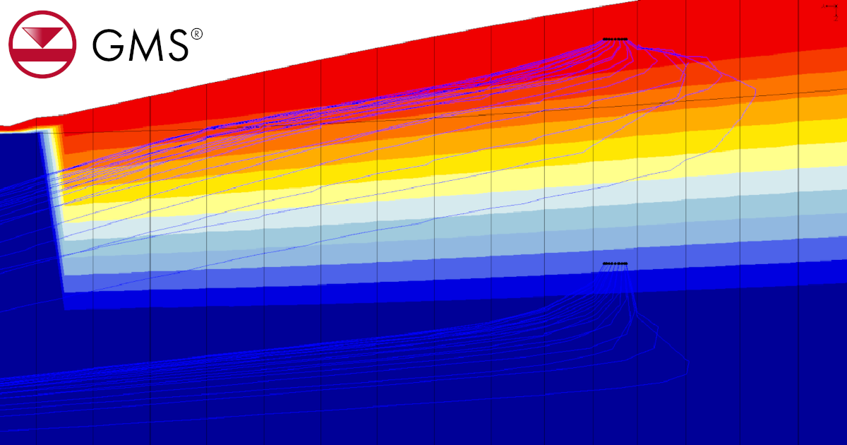
Step 4: Visualize Flow Paths and Travel Times
Once MODPATH completes, GMS brings groundwater movement to life with interactive 3D particle pathlines. Leverage GMS visualization tools to:
-
Color flow paths by travel time to instantly distinguish fast and slow pathways
-
Display time markers to clearly communicate when and how groundwater moves
-
Explore results in plan view, cross-section, or full 3D to reveal complex flow patterns
Together, these visual tools help uncover preferential flow paths, interlayer leakage, and delayed travel through low-permeability zones, turning model output into actionable insight.
Step 5: Interpret Results Carefully
Particle tracking in GMS provides powerful insight into groundwater movement, but it’s important to understand what the results represent. MODPATH simulates advective transport only, meaning flow paths illustrate average groundwater movement, not dispersion or chemical reactions. Applying this context ensures flow-path results strengthen, rather than oversimplify, your analysis. With this context ensures your conclusions are accurate, defensible, and professionally sound.
Final Thoughts
Groundwater models are most valuable when their results are easy to interpret and defend. Understanding where groundwater comes from, where it goes, and how long it takes to get there is essential for effective water-resource and contaminant-transport studies. Visualizing groundwater flow paths and travel times in GMS turns complex model output into insight you can see, trust, and explain. When built on a well-constructed MODFLOW flow model, MODPATH delivers a clear understanding of aquifer connectivity, travel times, and capture behavior, supporting confident technical and regulatory decisions.
Ready to take your groundwater modeling to the next level? Download GMS today and start turning model results into clear, defensible insight.
January 27, 2026
|
View: 2735
|
Categories: GMS
|
By: <a class="mp-info" href="https://aquaveo.com/blog/author/admin">Aquaveo Staff</a>
About the Author

Performing a Silent Install of XMS (Passwords & Hardware Locks)
October 10, 2018
Converting a NET File to an INP File
May 9, 2018
Computing Basin Curve Numbers in 9 Easy Steps
May 16, 2023
Performing a Silent Install for ALS
October 27, 2021
Tips for Finding Information on the XMS Wiki
September 25, 2019
Tips for Using Wells with MODFLOW 6
July 14, 2026
Enhanced Arc Geometry and Vertex Tools
July 7, 2026
SRH-2D Inflow & Outflow Best Practices
June 30, 2026