We use cookies to make your experience better. To comply with the new e-Privacy directive, we need to ask for your consent to set the cookies. Learn more.

Unlock the Potential of Boundary Conditions in the Map Module
If you’ve ever set 2D hydraulic model boundary conditions the old way—node by node—you know it’s a tedious, click-heavy process. It’s manageable with a few dozen nodes. But when you’re dealing with thousands of nodes, it can turn into an hours-long grind that eats into valuable project time.
What if there was a way to set all those boundary conditions in just a few clicks? That’s exactly what the Map Module in the Surface-water Modeling System (SMS) was built to do.
Why the Old Way Is Holding You Back
In older 2D hydraulic modeling workflows, you manually select and assign attributes to each node along your boundary. For small meshes, it’s fine. But large projects—think floodplain mapping, storm surge modeling, or river hydraulics—can have thousands of nodes to update. Every adjustment means more clicks, more chances for mistakes, and more fatigue.
This method not only slows you down but also makes quick scenario testing a headache.
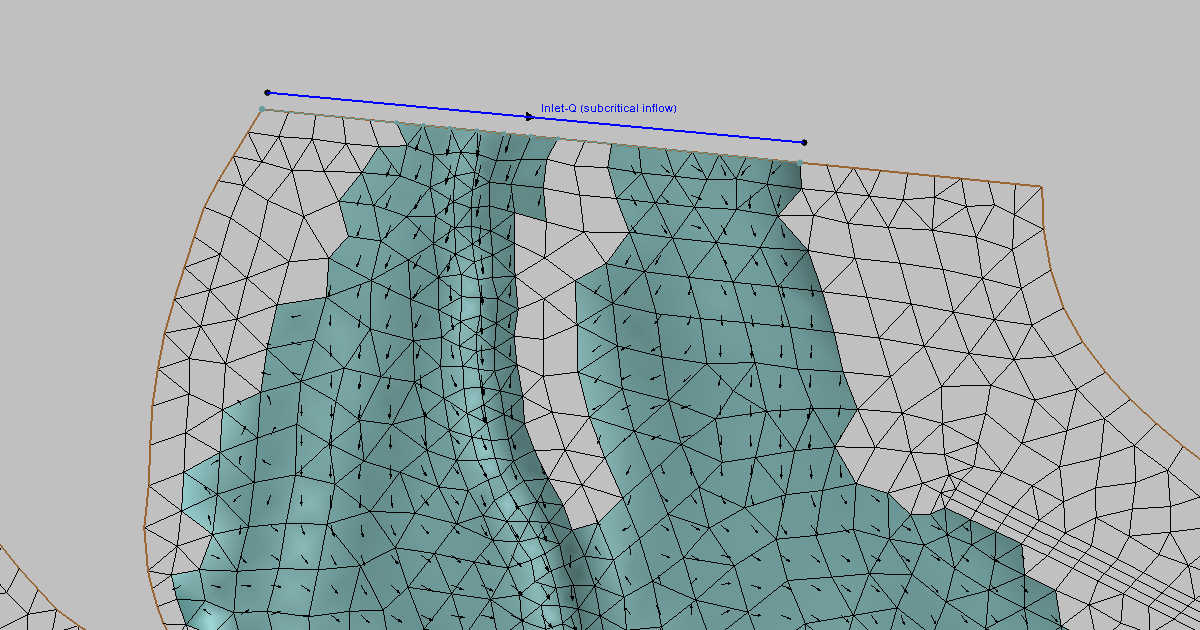
The Map Module Advantage
With the Map Module, you skip all the tedious node-by-node editing. Instead, you:
-
Draw an Arc along your model boundary where inflows, outflows, or structures occur.
-
Assign Boundary Conditions (time series, fixed stages, rating curves, etc.) to the arc.
-
Let SMS Handle the Rest—it automatically determines which mesh cells or nodes those conditions apply to during export.
Whether your model has 50 nodes or 5,000, the effort is the same. The Map Module handles the alignment for you.
How It Works Behind the Scenes
When you export your simulation files, SMS “snaps” your arcs to the nearest mesh nodes or cell faces. This ensures the boundary conditions are applied exactly where they belong—without you manually chasing each one.
The only thing to watch out for? Arc quality. Poorly drawn arcs can cause jagged boundaries or mismatches. Arcs drawn in poor locations can also confuse the software when snapping. Keep arcs clean, simple, and aligned with mesh or element edges for the best results.
The Payoff: Faster, Cleaner, Smarter Modeling
By switching to the Map Module for boundary conditions, you:
-
Cut setup time from hours to minutes
-
Reduce human error from repetitive manual edits
-
Make boundary adjustments easy when running multiple scenarios
-
Improve accuracy with clean, consistent snapping
For projects with tight deadlines, this workflow upgrade can mean the difference between barely delivering on time and having bandwidth to refine and validate your model. Take advantage of the many features in Map Module today by downloading SMS!
September 2, 2025
|
View: 4414
|
Categories: SMS
|
By: <a class="mp-info" href="https://aquaveo.com/blog/author/admin">Aquaveo Staff</a>
About the Author

Performing a Silent Install of XMS (Passwords & Hardware Locks)
October 10, 2018
Computing Basin Curve Numbers in 9 Easy Steps
May 16, 2023
Converting a NET File to an INP File
May 9, 2018
Performing a Silent Install for ALS
October 27, 2021
Tips for Finding Information on the XMS Wiki
September 25, 2019
Tips for Modeling Bridge Scour
May 19, 2026
Essential Guide to WMS Rain-on-Grid Modeling
May 5, 2026
Best Practices for Modeling Complex Geometries
April 28, 2026
Managing MODFLOW 6 Data: Lists, Copy Period & CSVs
April 21, 2026