We use cookies to make your experience better. To comply with the new e-Privacy directive, we need to ask for your consent to set the cookies. Learn more.

How to Create and Export Stream Networks from Terrain Data
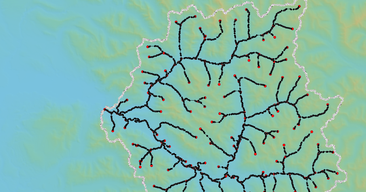
Stream networks form the backbone of watershed modeling, guiding runoff from upland areas to basin outlets. The Watershed Modeling System (WMS) offers powerful tools to automatically extract stream networks from terrain data, saving time and improving model accuracy. This guide walks through how to create and export stream networks in WMS for use in hydrologic or hydraulic models.
Step 1: Import Terrain Data
Start by importing a Digital Elevation Model (DEM) or other terrain dataset into WMS:
-
USGS 3DEP: Free elevation data available!
-
SRTM DEMs: Global coverage available via NASA and USGS Earth Explorer
Once downloaded, use File → Open in WMS to bring the DEM into your project. Ensure the terrain covers the full watershed area. Making use of the WMS’s data download tools, such as the Get Data tool and the Import from Web tool.
Step 2: Perform Watershed Delineation
With the DEM loaded, WMS can delineate flow directions and accumulation:
-
Go to DEM → Compute Flow Directions.
-
Run DEM → Compute Flow Accumulation to identify where water naturally converges.
-
Define a threshold accumulation value that represents when flow becomes a channel (for example, 1% of watershed area).
This process automatically traces the stream network across the terrain. The Hydrologic Modeling Wizard can also be used to quickly define the streams network. Furthermore, tools in the Toolbox, such as the Stream from Rasters tool and the Watershed Delineation tool can quickly generate a stream network. WMS provides multiple ways for you to get a delineated stream network of a watershed area.
Step 3: Review and Edit the Stream Network
Once WMS generates the network:
-
Use the Display Options to overlay streams on the DEM.
-
Adjust the threshold if streams appear too dense or sparse.
-
Manually edit stream segments if necessary using the Map Module tools.
Step 4: Export the Stream Network
Exporting stream networks allows you to use them in other hydrologic or hydraulic software:
-
Select the stream network coverage. Make certain that only this coverage is active. It is usually best to hide other coverages, grids, files, etc.
-
Go to File | Save As and export as a Shapefile (*.shp), GeoTIFF (*.tif), or other GIS format.
-
The exported file can then be used in HEC-HMS, HEC-RAS, or GIS applications like ArcGIS and QGIS.
Why This Matters
Accurately delineated stream networks ensure realistic runoff routing and hydraulic connectivity in watershed models. WMS makes it straightforward to convert DEMs into usable stream networks, saving time and reducing manual errors. The stream networks created in WMS can be used for almost any watershed modeling project. Get ahead with your watershed modeling projects and download WMS today!
September 30, 2025
|
View: 3289
|
Categories: WMS
|
By: <a class="mp-info" href="https://aquaveo.com/blog/author/admin">Aquaveo Staff</a>
About the Author

Performing a Silent Install of XMS (Passwords & Hardware Locks)
October 10, 2018
Converting a NET File to an INP File
May 9, 2018
Computing Basin Curve Numbers in 9 Easy Steps
May 16, 2023
Performing a Silent Install for ALS
October 27, 2021
Tips for Finding Information on the XMS Wiki
September 25, 2019
Tips for Using Wells with MODFLOW 6
July 14, 2026
Enhanced Arc Geometry and Vertex Tools
July 7, 2026
SRH-2D Inflow & Outflow Best Practices
June 30, 2026
Troubleshooting Projection and Coordinate System Issues
June 23, 2026