We use cookies to make your experience better. To comply with the new e-Privacy directive, we need to ask for your consent to set the cookies. Learn more.

How to Convert Land Use and Soil Data to Curve Numbers
Accurate hydrologic modeling in the Watershed Modeling System (WMS) depends on reliable runoff estimation. One of the most widely used methods for this is the SCS Curve Number (CN) method, which estimates runoff based on land use, soil type, and hydrologic condition. In WMS, you can easily convert land use and soil data into a Curve Number grid, streamlining your model setup and improving simulation accuracy.
Step 1: Obtain Land Use and Soil Data
To create a CN grid, you’ll need:
-
Land Use/Land Cover Data: Download the NLCD dataset from sites such as the Multi-Resolution Land Characteristics Consortium (MRLC):
https://www.mrlc.gov -
Soil Data (SSURGO or STATSGO): Available from the USDA NRCS Web Soil Survey:
https://websoilsurvey.sc.egov.usda.gov
Download both datasets in GIS-compatible formats, such as GeoTIFF or shapefile. This data can also be optain through the WMS interface.
Step 2: Import Data into WMS
-
Open your project in WMS.
-
Use GIS Data → Add Data to import both the land use and soil layers.
-
Ensure the coordinate systems match your watershed project area.
-
Clip the datasets to the watershed boundary using the Extract → By Polygon tool if needed.
-
Other options for importing data can be found using the Get Data tool or the Import from Web tool.
Step 3: Map Land Use and Soil Data to Curve Numbers
-
Create map coverages set to the land use type of land use data and the soil type for soil data.
-
Use the Mapping | Shapes → Feature Objects command to convert the imported land use and soil type data to their respective coverages.
-
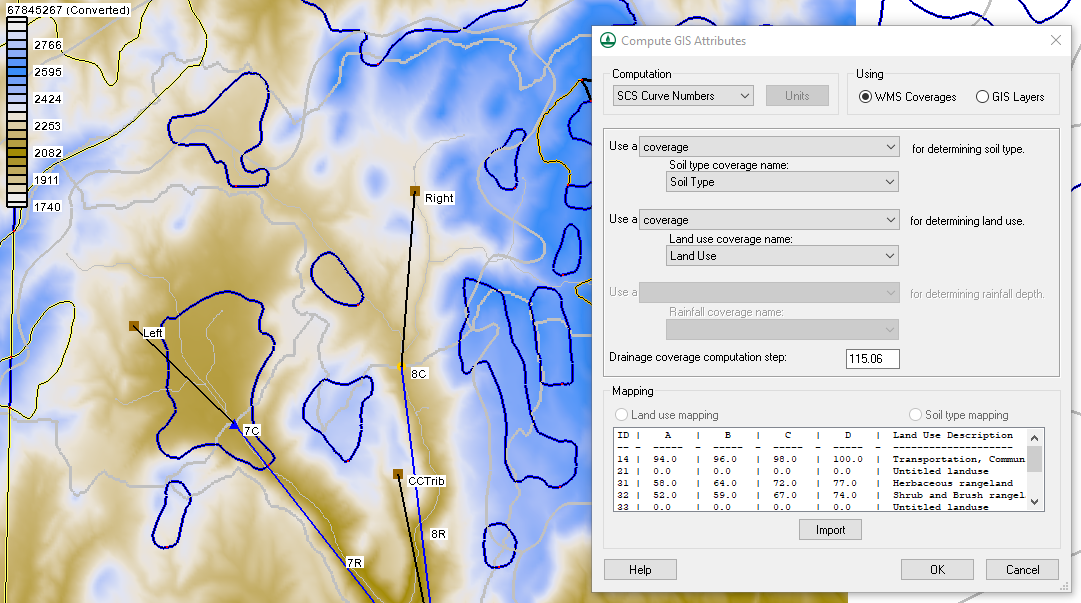
Switch to the Drainage Module and go to Calculators | Compute GIS Attributes….
-
Select the SCS Curve Numbers option.
-
Use the Land Use Table and Soil Hydrologic Group Table to link your imported land use and soil categories to appropriate CN values.
-
WMS includes default lookup tables for NLCD and SSURGO datasets based on USDA TR-55 guidelines (USDA NRCS, 1986).
Step 4: Review and Assign the Curve Number Grid
Once the curve numbers are assigned:
-
View it in the Map Module to ensure values look reasonable.
-
Use the Drainage Basin Delineation Tools to assign average CN values to each basin.
Why This Matters
Automating the conversion of land use and soil data to curve numbers in WMS not only saves time but also ensures consistency with industry-standard methods. The resulting CN grid enhances runoff simulations in models like HEC-HMS and HSPF.
Make use of curve numbers in your WMS projects today!
August 19, 2025
|
View: 8327
|
Categories: WMS
|
By: <a class="mp-info" href="https://aquaveo.com/blog/author/admin">Aquaveo Staff</a>
About the Author

Performing a Silent Install of XMS (Passwords & Hardware Locks)
October 10, 2018
Converting a NET File to an INP File
May 9, 2018
Computing Basin Curve Numbers in 9 Easy Steps
May 16, 2023
Performing a Silent Install for ALS
October 27, 2021
Tips for Finding Information on the XMS Wiki
September 25, 2019
Tips for Using Wells with MODFLOW 6
July 14, 2026
Enhanced Arc Geometry and Vertex Tools
July 7, 2026
SRH-2D Inflow & Outflow Best Practices
June 30, 2026
Troubleshooting Projection and Coordinate System Issues
June 23, 2026