We use cookies to make your experience better. To comply with the new e-Privacy directive, we need to ask for your consent to set the cookies. Learn more.

Converting a Lidar File to a DEM in WMS
Do you have a lidar file that you would like to convert into a DEM file? WMS can help you with this. Lidar files can contain a large amount of 3D points used for representing features on the Earth’s surface. DEMs can be derived from high-resolution LIDAR data, and we have developed a workflow that can do this. This post will review how to convert LIDAR files to DEM files quickly and easily in WMS.
This can be done by using the following workflow:
- Use any of the methods to open files to import your lidar files into your WMS project.
- If you have more than one lidar file imported into the GIS module, select all of the separate files and then right-click one of them and select Merge… to open the Lidar File dialog where you can name and save your merged lidar file.
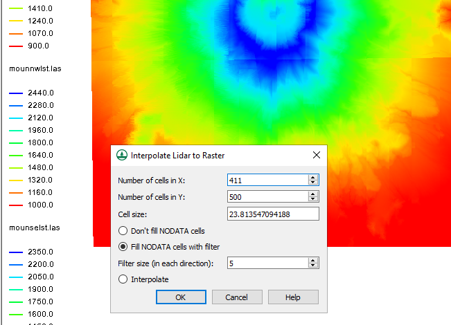
- After you have imported your lidar file, right-click it in the Project Explorer and select Interpolate to | Raster… to open the Interpolate Lidar to Raster dialog.
- Review the settings and click OK when they are all set correctly.
- In the Raster File dialog, set the name and type for the raster file and then click Save to close the dialog and save the raster file.
- When done generating the raster and updating the display, right-click the new raster file in the GIS module and select Convert to | DEM to open the Resample and Export Raster dialog.
- Review the settings and click OK when they are all set correctly.
- You should now have a DEM file of the same area as your lidar files. Hide everything in the GIS module to view the DEM file on its own.
It should be noted that if you have multiple lidar files, you can convert each file individually rather than merging them all together as was done in Step 2. The merge makes the final product easier and quicker to accomplish.
Try out converting lidar files to DEMs in WMS today!
June 2, 2021
|
View: 3483
|
Categories: WMS
|
By: <a class="mp-info" href="https://aquaveo.com/blog/author/admin">Aquaveo Staff</a>
About the Author

Performing a Silent Install of XMS (Passwords & Hardware Locks)
October 10, 2018
Computing Basin Curve Numbers in 9 Easy Steps
May 16, 2023
Converting a NET File to an INP File
May 9, 2018
Performing a Silent Install for ALS
October 27, 2021
Tips for Finding Information on the XMS Wiki
September 25, 2019
Comparing Multiple Design Alternatives in One Project
April 7, 2026
Incorporating MODFLOW 6 Groundwater Energy (GWE)
March 31, 2026
Essential DEM Clean-Up for Watershed Delineation
March 24, 2026
Essential Boundary Condition Guide
March 17, 2026
How to Delineate a Well Capture Zone Using MODPATH
March 10, 2026