We use cookies to make your experience better. To comply with the new e-Privacy directive, we need to ask for your consent to set the cookies. Learn more.
What's New in Arc Hydro Groundwater
The following is a list of the more significant changes and new features available in AHGW Pro 1.0 for ArcGIS Pro.
Keep your license current by paying annual maintenance to continue receiving all available updates, releases, and technical support. New licenses include maintenance for 1 full year.
AHGW for ArcGIS Pro Now Available
AHGW Pro 1.0 is now available for ArcGIS Pro 3.0. Arc Hydro Groundwater 1.0 includes the Groundwater Analyst and Subsurface Analyst tools that ArcGIS Desktop users have come to rely on for many years.
The following is a list of the more significant changes and new features available in AHGW 3.5 for ArcGIS Desktop.
Keep your license current by paying annual maintenance to continue receiving all available updates, releases, and technical support. New licenses include maintenance for 1 full year.
New Software-based Licensing
AHGW 3.5 offers 2 new licensing methods including Local and Flex licenses that are software based - no hardware required! Existing users will have the option of migrating to either method at their next maintenance renewal. Learn more
- Local license: Designed for use on a single computer and offers support for Remote Desktop & virtual machines
- Flex license: Offers the flexibility of sharing a license on your network as well as a check-out / check-in feature for remote work
ArcGIS 10.8 Compatible
AHGW 3.5 now supports ESRI's release of ArcGIS 10.8 as well as 10.7 & 10.6.
The following is a list of the more significant changes and new features available in AHGW 3.4.
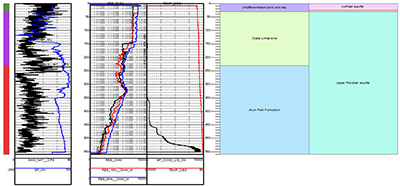
Geophysical Plot Tools
AHGW now includes geoprocessing tools for adding an XS2D display with multiple geophysical plots for a single well. Using a geophysical data table (such as one imported from a Log ASCII Standard file), multiple geophysical variables can be plotted alongside a well, with individual data scales (linear or logarithmic).
The Create Geophysical Plot Wizard can be used to create a new XS2D from a selected well.
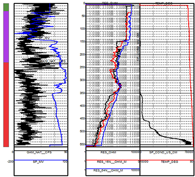
Lithostratigraphic and Hydrostratigraphic Display
Lithostratigraphic and hydrostratigraphic units can be plotted next to the geophysical data. The lithostratigraphy and hydrostratigraphy features are created with a new geoprocessing tool, which can be automated as an optional step in the Create Geophysical Plot Wizard.
ArcGIS 10.5 Compatible
AHGW 3.4 now supports ESRI's release of ArcGIS 10.7 as well as 10.6, 10.5, & 10.4.
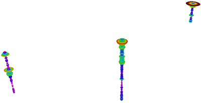
3D Geophysical Log Plots
A new geoprocessing tool creates subsurface 3D geophysical features for a well based on data in a geophysical data table. Given a set of Well features, a geophysical depth field and a geophysical variable field, 3D (Z-enabled) features are created in a new feature class that is best viewed in ArcScene. The size of the concentric circles representing the geophysical data varies by the values of the geophysical data, but can also be scaled in size based on user preference. The Extrusion layer properties in ArcScene can also be used to extrude the concentric circles between readings in the original geophysical log table. The proper extrusion value is calculated as one of the attribute fields in the output feature class created by the tool.
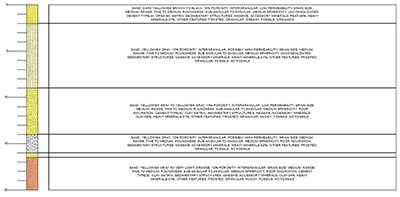
Lithological Description Tools
Geoprocessing tools for adding an XS2D display (typically in a new data frame) showing a detailed lithological description by depth. Using a table of lithological descriptions associated with a from depth and to depth, a new display can be created showing a detailed text description of the lithology of a borehole.
The Create Lithological Description Wizard automates the process.