We use cookies to make your experience better. To comply with the new e-Privacy directive, we need to ask for your consent to set the cookies. Learn more.

Build Watershed and Streams from Raster Data
Delineating a watershed area into a usable model can be a daunting process. Two new tools in the Surface-water Modeling System (SMS) Toolbox make defining a watershed domain quick and easy. Introducing the Streams from Rasters and the Watershed from Rasters tools.
These two tools are found in the Coverages folder in the Toolbox.These two tools can extract data from an imported raster to automatically generate the feature objects for watershed streams and domains for your SMS model.
The first tool, Streams from Raster, will evaluate the raster elevation data, extract the direction of runoff, create connected arcs, and put it into a separate coverage for you. You’ll need a directional raster in order to run the tool.
The Streams from Raster tool will show the entire runoff flow based on elevation in the selected raster. If water starts here, then it will go in that direction until it ends up there in that stream bed. You can see and trace the most likely paths for water flow until it hits the lowest point possible for that flow path. This can help you plan where to place your stream arcs for your model.
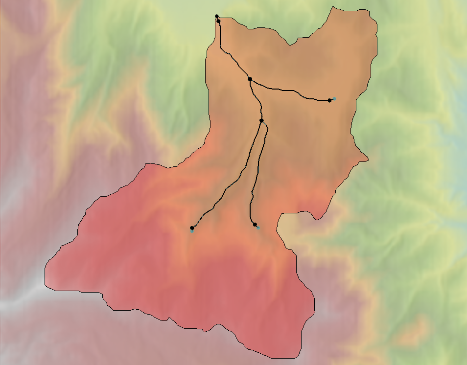
The Watershed from Rasters tool creates a domain of the watershed area. This tool uses an amalgamation of several processes that operate in a particular order in the background as the tool runs. Several of these processes have been added to the Toolbox, including Streams from Raster, to run as separate tools, if desired. Once run, you will end up adding feature objects that define a domain to a coverage.
Then, the feature objects can be used to create a geometry (2D or 3D meshes or UGrids, etc.) of the watershed area. By using the Watershed from Raster tool, it enhances the speed at which a model can be created.
Head on over to SMS and try delineating a watershed with these new tools in your next model.
August 27, 2024
|
View: 3218
|
Categories: SMS
|
By: <a class="mp-info" href="https://aquaveo.com/blog/author/admin">Aquaveo Staff</a>
About the Author

Performing a Silent Install of XMS (Passwords & Hardware Locks)
October 10, 2018
Computing Basin Curve Numbers in 9 Easy Steps
May 16, 2023
Converting a NET File to an INP File
May 9, 2018
Performing a Silent Install for ALS
October 27, 2021
Tips for Finding Information on the XMS Wiki
September 25, 2019
5 Concepts for Mastering Surface-water Modeling
April 14, 2026
Comparing Multiple Design Alternatives in One Project
April 7, 2026
Incorporating MODFLOW 6 Groundwater Energy (GWE)
March 31, 2026
Essential DEM Clean-Up for Watershed Delineation
March 24, 2026
Essential Boundary Condition Guide
March 17, 2026