We use cookies to make your experience better. To comply with the new e-Privacy directive, we need to ask for your consent to set the cookies. Learn more.
What's new in GMS 10.8
The following is a list of the more significant changes and new features available in GMS 10.8.
Keep your license current by paying annual maintenance to continue receiving all available updates, releases, and technical support. New licenses include maintenance for 1 full year.
HydroGeoSphere Interface
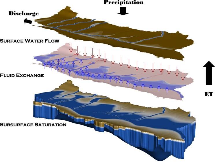
GMS 10.8 offers a new interface to the HydroGeoSphere (HGS) model. HGS is a powerful, fully-integrated hydrologic modeling platform used to model overland/surface water flow and variably saturated groundwater flow. Unprecedented environmental challenges and complex, unpredictable water systems require an integrated, physics-based approach to hydrologic modeling. HGS offers tools to improve understanding of hydrologic systems for enhanced decision support, increase operational efficiency, and promote interdisciplinary collaboration between groundwater and surface water teams. Watch quick clip
MODFLOW-USG Transport v2.1.1
The latest version of MODFLOW-USG (v2.1.1) is supported in GMS 10.8.
mod-PATH3DU v2.1.7
The latest version of mod-PATH3DU (v2.1.7) is supported in GMS 10.8.
MODFLOW 6 v6.4.2
The latest version of MODFLOW 6 (v6.4.2) is supported in GMS 10.8.
PEST v17.5
The latest version of PEST (v17.5) is supported in GMS 10.8.
Improved Character Support
Datasets now support non-English characters.
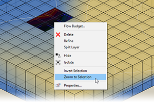
Improved Selection Feedback
The list of selected UGrid cell/point IDs are displayed in the selection feedback.
Improved Legend
The legend can now include dataset units and time units via “UNITS” and “TUNITS” in the Contour Legend Dialog. Watch quick clip
Improved SAMG Solver with New Features
Solve MODFLOW solutions quickly in serial or parallel with this newly updated solver. The base version includes machine learning tools to autonomously adapt to specific simulations resulting in faster solutions.
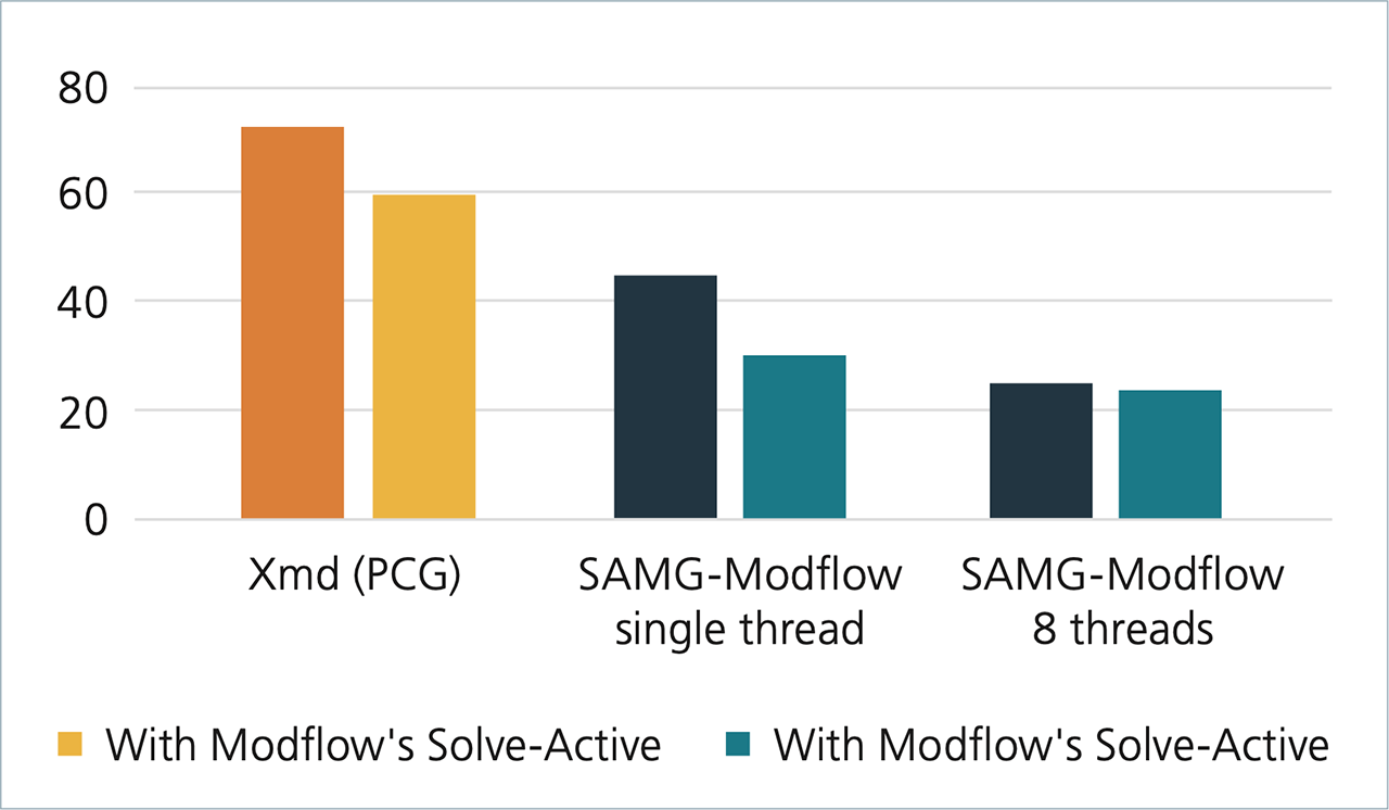
Both versions support MODFLOW 2000, 2005, MODFLOW-USG, and MODFLOW 6.
The SAMG-MODFLOW+ add-on offers support for transport modeling and connected linear network (CLN) problems.
User Feature Requests
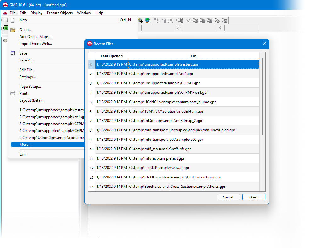
Files listed in the more Recent Files window from the File menu may be right-clicked to open the containing folder. Watch quick clip
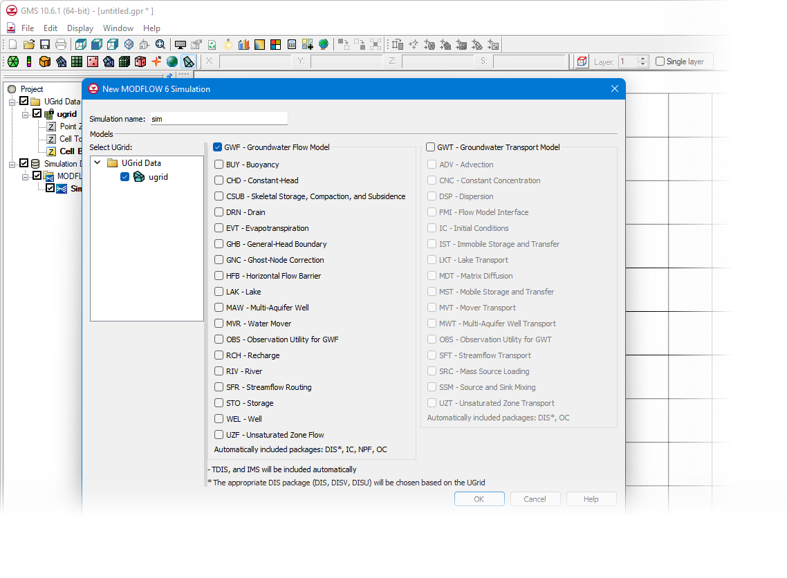
MODFLOW 6
- Flow Budget - Watch quick clip
- Velocity Vectors - Watch quick clip
- HFB Package, Map to Coverage - Watch quick clip
- Starting Heads = top elevation options - Watch quick clip
- Units in table heading tool tips - Watch quick clip
- Open in Explorer command
MODFLOW-USG
- Find and set “pass-through cells” for the MODFLOW-USG DISU Package - Watch quick clip
- DRT & ETS Packages now fully supported for MODFLOW-USG - Watch quick clip
- RCH, EVT, ETS packages allow the use of 3D Datasets to define input arrays. Previously there was only an option to use 2D Datasets on matching 2D structured grids. - Watch quick clip
- The RCH, EVT, and ETS Packages offer a method to populate input array values from one or more rasters using the Rasters to Array feature. (structured and unstructured grids) - Watch quick clip
MODFLOW-USG Transport
- Find and set “pass-through cells” for the MODFLOW-USG DISU Package - Watch quick clip
- DRT & ETS Packages now fully supported for MODFLOW-USG Transport - Watch quick clip
- RCH Package support for SEEPELEV and CONCENTRATION - Watch quick clip
- EVT Package support for ETFACTOR - Watch quick clip
- RCH, EVT, ETS packages allow the use of 3D Datasets to define input arrays. Previously there was only an option to use 2D Datasets on matching 2D structured grids. - Watch quick clip
- The RCH, EVT, and ETS Packages offer a method to populate input array values from one or more rasters using the Rasters to Array feature. (structured and unstructured grids) - Watch quick clip
New Color Ramp Dialog
GMS 10.8 includes a new color ramp dialog. The tool features new ramps along with those previously available. Users can quickly view, select, and reverse ramps as well as mark them as favorites. - Watch quick clip
Additional Keyboard Shortcut
Select all cells in UGrid layer using “l” (L) key.
3D UGrid from Rasters Tool
Create a 3D UGrid using one or more rasters contained in the project. Watch quick clip
Tutorials
New tutorials are now available for:
- MODFLOW 6 MDT 3D
- HydroGeoSphere - Surface Flow & Evapotranspiration
- HydroGeoSphere - Porous Media Domain
- HydroGeoSphere - Post-Processing
As always, our comprehensive tutorials are free to download and provide step-by-step instruction on using GMS. Download tutorials at the GMS Learning Center
What's new in GMS 10.7
The following is a list of the more significant changes and new features available in GMS 10.7.
MODFLOW 6
GMS 10.7 adds support for steady state and transient PEST observations. New MODFLOW 6 features and the latest MF6 executable are also included along with updates to the MDT package as well as other improvements and bug fixes.
UGrid Layer Visualization
Visualize the top or bottom of a UGrid layer or visualize both to make comparisons.
Create Cross Sections
GMS 10.7 includes new tools for creating cross sections through a UGrid. Similar to cross sections in 3D Grids and 3D Meshes, UGrid cross sections can also be moved back and forth and rotated using the "Edit Plane" tool and can also be moved vertically above or below the UGrid.
GMS Toolbox
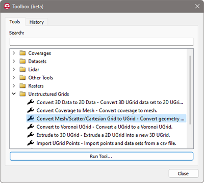
A new, general-purpose toolbox is now available in beta that allows GMS to execute Python scripts. These new tools help automate and simplify many workflows.
- Geometric Data: Manipulate and edit UGrids
- Map Module: Manipulate coverage data, trim arcs using polygons, convert arcs to polygons
- GIS Data: Manipulate raster and Lidar data, blend rasters, and perform multisource raster interpolation
- Datasets: Perform mathematical operations and operate on datasets attached meshes, scatter sets, or UGrids
- Other tools: Numerous additional tools are available and new tools will be added in future updates of GMS
Tutorials
New tutorials are now available for:
- GMS Toolbox
- MODFLOW-USG Transport - MDT 3D
- MODFLOW 6 - MDT Discrete Fracture
- MODFLOW 6 - MDT Equivalent Porous
- MODFLOW 6 - MDT Sand Tank
- MODFLOW 6 - PEST Observations, Steady State
- MODFLOW 6 - PEST Observations, Transient
- MODFLOW 6 - ZONEBUDGET
As always, our comprehensive tutorials are free to download and provide step-by-step instruction on using GMS. Download tutorials at the GMS Learning Center
What's new in GMS 10.6
The following is a list of the more significant changes and new features available in GMS 10.6.
MODFLOW 6
GMS 10.6 supports all flow and transport capabilities in MODFLOW 6 in a more reponsive user interface with improved map coverage functionality. All packages in v6.2.1 are supported.
MODFLOW-USG-Transport Updates
The latest version of MODFLOW-USG-Transport (v1.8) is now supported in GMS 10.6 and includes support for the following packages:
- MDT package (matrix diffusion)
- SMS package - SOLVEACTIVE, DAMPBOT, SHIFT, TRUNCATEDNEWTON
- RIV package - MERGE_BED_K1
- WEL package - WELLBOT
Customer Feature Requests
Raster Display Options - Separate contour options for each raster (first introduced in 10.5.5).
Recent files list - "More" option to see an expanded list of recently opened files.
MODFLOW-NWT v1.2
The latest version of MODFLOW-NWT (v1.2) is now supported in GMS 10.6.
mod-PATH3DU v2.1.5
The latest version of mod-PATH3DU (v2.1.5) is now supported in GMS 10.6.
Tutorials
New tutorials are now available for:
- MODFLOW 6 - Conceptual Model Approach
- MODFLOW 6 - Evapotranspiration
- MODFLOW 6 - Stream Package
- MODFLOW 6 - Building a Transient Model
- MODFLOW 6 - Transport Grid Approach
- MODFLOW 6 - Transport Uncoupled
As always, our comprehensive tutorials are free to download and provide step-by-step instruction on using GMS. Download tutorials at the GMS Learning Center
What's new in GMS 10.5
The following is a list of the more significant changes and new features available in GMS 10.5.
MODFLOW 6 Beta
Support for MODFLOW 6 is now in beta for GMS 10.5. This new version of MODFLOW allows users to define traditional grids or unstructured grids. GMS 10.5 with MODFLOW 6 offers a simulation based approach allowing users to develop any number of simulations in a single project that can share common information.
TVM Package
GMS 10.5 includes support for the Time-Variant Materials (TVM) package with MODLOW-USG Transport. The TVM package allows hydraulic conductivity and storage values to be changed as a step function between stress periods or in a continuous manner through a transient simulation.
Tile Map Services (TMS)
GMS 10.5 includes support for the Time-Variant Materials (TVM) package with MODLOW-USG Transport. The TVM package allows hydraulic conductivity and storage values to be changed as a step function between stress periods or in a continuous manner through a transient simulation.
Faster Display of Large Rasters
GMS 10.5 includes support for the Time-Variant Materials (TVM) package with MODLOW-USG Transport. The TVM package allows hydraulic conductivity and storage values to be changed as a step function between stress periods or in a continuous manner through a transient simulation.
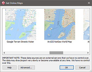
Additional Map Services
New data sources from Google and ArcGIS have been added to the “Get Online Maps” tool.
New Software-based Licensing
GMS 10.5 offers 2 new licensing methods including Local and Flex licenses that are software based - no hardware required! Existing users will have the option of migrating to either method at their next maintenance renewal. Learn more
- Local license: Designed for use on a single computer and offers support for Remote Desktop & virtual machines
- Flex license: Offers the flexibility of sharing a license on your network as well as a check-out / check-in feature for remote work
Updated SAMG Solver with MF6 Support
The latest version of the SAMG Solver includes support for MODFLOW 6 and will soon be available in GMS 10.5. Purchase a new license with support for SAMG and MF6 or add it to an existing license that is current on annual maintenance.
Updated SAMG Solver with MF6 Support
The latest version of the SAMG Solver includes support for MODFLOW 6 and will soon be available in GMS 10.5. Purchase a new license with support for SAMG and MF6 or add it to an existing license that is current on annual maintenance.
Customer Feature Requests
The latest version of the SAMG Solver includes support for MODFLOW 6 and will soon be available in GMS 10.5. Purchase a new license with support for SAMG and MF6 or add it to an existing license that is current on annual maintenance.
Tutorials
New tutorials are now available for the MODFLOW 6 Grid Approach as well as the MODFLOW-USG Transport TVM Package. As always, our comprehensive tutorials are free to download and provide step-by-step instruction on using GMS. Download tutorials at the GMS Learning Center
Improved Snapping
The latest version of the SAMG Solver includes support for MODFLOW 6 and will soon be available in GMS 10.5. Purchase a new license with support for SAMG and MF6 or add it to an existing license that is current on annual maintenance.
What's new in GMS 10.4
The following is a list of the more significant changes and new features available in GMS 10.4.
MODFLOW-USG-Transport
GMS 10.4 supports MODFLOW-USG-Transport for transport modeling capabilities in MODFLOW-USG. MODFLOW-USG package support now includes BCT (Block Centered Transport), DDF (Density Dependent Flow), DPT (Dual Porosity Transport), and PCB (Prescribed Concentration Boundary).
MODFLOW 6
GMS 10.5 includes support for the Time-Variant Materials (TVM) package with MODLOW-USG Transport. The TVM package allows hydraulic conductivity and storage values to be changed as a step function between stress periods or in a continuous manner through a transient simulation.
mod-PATH3DU Version 2.0
GMS 10.5 includes support for the Time-Variant Materials (TVM) package with MODLOW-USG Transport. The TVM package allows hydraulic conductivity and storage values to be changed as a step function between stress periods or in a continuous manner through a transient simulation.
Contour labels on UGrids
GMS 10.5 includes support for the Time-Variant Materials (TVM) package with MODLOW-USG Transport. The TVM package allows hydraulic conductivity and storage values to be changed as a step function between stress periods or in a continuous manner through a transient simulation.
CLN Observation Wells
New data sources from Google and ArcGIS have been added to the “Get Online Maps” tool.
LIDAR Management
GMS now supports advanced LIDAR data handling tools for reading, viewing, and converting LIDAR data to other formats for use with your model. Large LIDAR datasets are efficiently displayed with options to specify the number of points visualized and exclusion extents.
More responsive background images
The latest version of the SAMG Solver includes support for MODFLOW 6 and will soon be available in GMS 10.5. Purchase a new license with support for SAMG and MF6 or add it to an existing license that is current on annual maintenance.
Updated SAMG Solver with MF6 Support
The latest version of the SAMG Solver includes support for MODFLOW 6 and will soon be available in GMS 10.5. Purchase a new license with support for SAMG and MF6 or add it to an existing license that is current on annual maintenance.
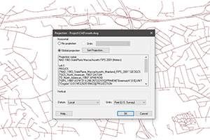
New Projection & Coordinate System Options
The new projections dialog comes with an extensive library of geographic and projected coordinate systems as well as a search feature to quickly find a desired projection. The dialog keeps track of recently used projections and allows the user to save projections as favorites so they are readily available. EPSG codes can also be used to define a projection, and projections can be imported from .prj files.
Tutorials
New tutorials are now available for Conceptual Modeling (4), MODFLOW-USG-Transport, Save to MODFLOW 6, CLN Observation Wells, Lidar, and Lidar with Multiple Files. The Projections tutorial has also been updated. As always, our comprehensive tutorials are free to download and provide step-by-step instruction on using GMS.
Download tutorials at the GMS Learning Center
What's new in GMS 10.3
The following is a list of the more significant changes and new features available in GMS 10.3.
MT3D-USGS
GMS 10.4 supports MODFLOW-USG-Transport for transport modeling capabilities in MODFLOW-USG. MODFLOW-USG package support now includes BCT (Block Centered Transport), DDF (Density Dependent Flow), DPT (Dual Porosity Transport), and PCB (Prescribed Concentration Boundary).
PEST 14.0
The latest version of PEST (v14.0) is now supported in GMS.
MODFLOW-NWT 1.1.2
GMS 10.5 includes support for the Time-Variant Materials (TVM) package with MODLOW-USG Transport. The TVM package allows hydraulic conductivity and storage values to be changed as a step function between stress periods or in a continuous manner through a transient simulation.
Zone flow
GMS 10.5 includes support for the Time-Variant Materials (TVM) package with MODLOW-USG Transport. The TVM package allows hydraulic conductivity and storage values to be changed as a step function between stress periods or in a continuous manner through a transient simulation.
SYTP for HUF package
GMS 10.5 includes support for the Time-Variant Materials (TVM) package with MODLOW-USG Transport. The TVM package allows hydraulic conductivity and storage values to be changed as a step function between stress periods or in a continuous manner through a transient simulation.
Preserve DISU data created outside of GMS
GMS 10.5 includes support for the Time-Variant Materials (TVM) package with MODLOW-USG Transport. The TVM package allows hydraulic conductivity and storage values to be changed as a step function between stress periods or in a continuous manner through a transient simulation.
Tutorials
New tutorials are now available for mod-PATH3DU, MT3D-USGS, Shapefile to CLN, and Recharge. As always, our comprehensive tutorials are free to download and provide step-by-step instruction on using GMS.
Download tutorials at the GMS Learning Center
mod-PATH3DU
GMS now supports advanced LIDAR data handling tools for reading, viewing, and converting LIDAR data to other formats for use with your model. Large LIDAR datasets are efficiently displayed with options to specify the number of points visualized and exclusion extents.
The latest version of mod-PATH3DU (v1.1.0) is now supported in GMS and includes:
- New Waterloo method and modified grid specification file
- Support for DefaultIFACE
- Model Checker added to find obvious model setup errors
- Model Wrapper and automatic reading of the solution
- Export options to save shapefiles of pathlines, pathline points, and polygon capture zones
- Option to create starting locations from UGrid points or cell centers
Shapefile to CLN
The latest version of the SAMG Solver includes support for MODFLOW 6 and will soon be available in GMS 10.5. Purchase a new license with support for SAMG and MF6 or add it to an existing license that is current on annual maintenance.
Mapping SFR2 to multiple surface layers
The latest version of the SAMG Solver includes support for MODFLOW 6 and will soon be available in GMS 10.5. Purchase a new license with support for SAMG and MF6 or add it to an existing license that is current on annual maintenance.
Multiple UGrid Display Options & Split Layers
New data sources from Google and ArcGIS have been added to the “Get Online Maps” tool.
Hi-res Icons
High resolution displays caused icons and text in older versions of GMS to render very small. GMS now detects your display resolution and appropriately sizes icon bitmaps and fonts.
Additional Features
New tutorials are now available for Conceptual Modeling (4), MODFLOW-USG-Transport, Save to MODFLOW 6, CLN Observation Wells, Lidar, and Lidar with Multiple Files. The Projections tutorial has also been updated. As always, our comprehensive tutorials are free to download and provide step-by-step instruction on using GMS.
Download tutorials at the GMS Learning Center