FESWMS
Flow & Sediment Transport Modeling with SMS
Application:Riverine Modeling
Method:2D Finite Element
Developer:Federal Highway Administration
Why FESWMS with SMS?
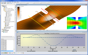
SMS provides a custom interface to the FESWMS model offering a simple way to set model parameters and a graphical user interface to run the model and visualize the results. Gather background data from a variety of sources from GIS to CAD and access online data from numerous databases of maps, images, and elevation data. SMS allows you to interact with models in true 3D taking advantage of optimized OpenGL graphics and to create photo-realistic renderings and animations for PowerPoint, print, and web presentations.
Try SMS Free for 14 Days >Purchase SMS with FESWMS >
FESWMS Description:
FESWMS is a hydrodynamic modeling code that supports both super and subcritical flow analyses, including area wetting and drying. It has been developed under funding by the U.S. Federal Highways Administration (FHWA) by Dr. Dave Froelich PE. FESWMS is specifically suited for modeling regions involving flow control structures, such as are encountered at the intersection of roadways and waterways. Specifically, the FESWMS model allows the user to include weirs, culverts, drop inlets, and bridge piers into a standard 2D finite element model. SMS provides graphical tools for defining these structures and controlling analysis using the FESWMS model. Both pre- and post-processing capabilities are included in the interface.


